You are here: Home > Network List > TA - USArray Transportable Network (new EarthScope stations) Stations List
> Station N47A Urbana, IN, USA > Earthquake Result Viewer
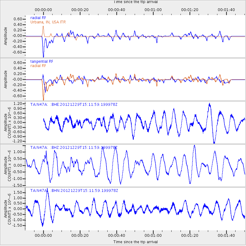
N47A Urbana, IN, USA - Earthquake Result Viewer
*The percent match for this event was below the threshold and hence no stack was calculated.
| Earthquake location: |
Near East Coast Of Honshu, Japan |
| Earthquake latitude/longitude: |
38.7/142.0 |
| Earthquake time(UTC): |
2012/12/29 (364) 14:59:38 GMT |
| Earthquake Depth: |
56 km |
| Earthquake Magnitude: |
5.5 MW, 5.4 MW, 5.4 MB |
| Earthquake Catalog/Contributor: |
WHDF/NEIC |
|
| Network: |
TA USArray Transportable Network (new EarthScope stations) |
| Station: |
N47A Urbana, IN, USA |
| Lat/Lon: |
40.88 N/85.69 W |
| Elevation: |
252 m |
|
| Distance: |
89.6 deg |
| Az: |
34.125 deg |
| Baz: |
324.646 deg |
| Ray Param: |
$rayparam |
*The percent match for this event was below the threshold and hence was not used in the summary stack. |
|
| Radial Match: |
60.533253 % |
| Radial Bump: |
400 |
| Transverse Match: |
73.37114 % |
| Transverse Bump: |
400 |
| SOD ConfigId: |
491031 |
| Insert Time: |
2013-04-10 04:43:05.474 +0000 |
| GWidth: |
2.5 |
| Max Bumps: |
400 |
| Tol: |
0.001 |
|
Signal To Noise
| Channel | StoN | STA | LTA |
| TA:N47A: :BHZ:20121229T15:11:59.199978Z | 1.8671016 | 6.949639E-7 | 3.7221537E-7 |
| TA:N47A: :BHN:20121229T15:11:59.199978Z | 3.1499925 | 1.0583643E-6 | 3.3598948E-7 |
| TA:N47A: :BHE:20121229T15:11:59.199978Z | 1.0816798 | 2.6593545E-7 | 2.4585415E-7 |
| Arrivals |
| Ps | |
| PpPs | |
| PsPs/PpSs | |


