You are here: Home > Network List > TA - USArray Transportable Network (new EarthScope stations) Stations List
> Station A36M Sachs Harbour, NT, CAN > Earthquake Result Viewer
A36M Sachs Harbour, NT, CAN - Earthquake Result Viewer
| Earthquake location: |
Rat Islands, Aleutian Islands |
| Earthquake latitude/longitude: |
52.2/176.6 |
| Earthquake time(UTC): |
2014/06/24 (175) 08:12:33 GMT |
| Earthquake Depth: |
23 km |
| Earthquake Magnitude: |
5.8 MW |
| Earthquake Catalog/Contributor: |
ISC/ISC |
|
| Network: |
TA USArray Transportable Network (new EarthScope stations) |
| Station: |
A36M Sachs Harbour, NT, CAN |
| Lat/Lon: |
71.99 N/125.25 W |
| Elevation: |
32 m |
|
| Distance: |
31.8 deg |
| Az: |
30.109 deg |
| Baz: |
263.096 deg |
| Ray Param: |
0.078895986 |
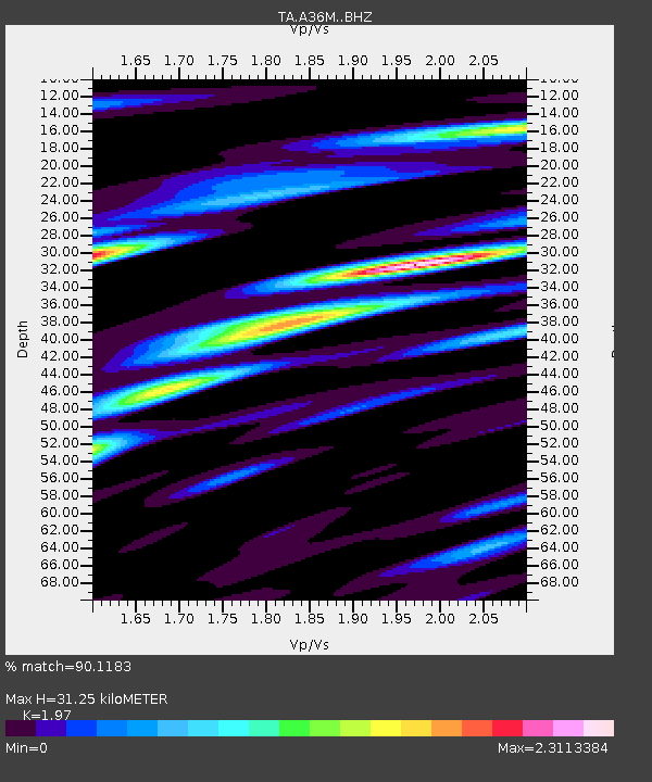
| Estimated Moho Depth: |
31.25 km |
| Estimated Crust Vp/Vs: |
1.97 |
| Assumed Crust Vp: |
6.24 km/s |
| Estimated Crust Vs: |
3.168 km/s |
| Estimated Crust Poisson's Ratio: |
0.33 |
|
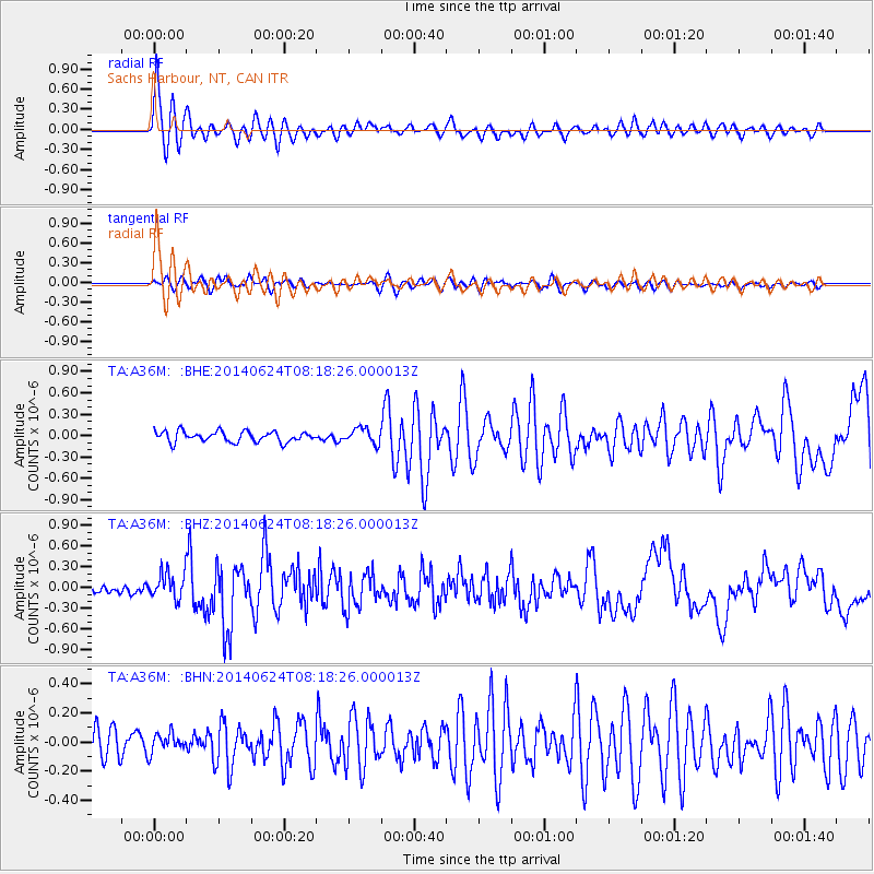
| Radial Match: |
90.1183 % |
| Radial Bump: |
400 |
| Transverse Match: |
68.90743 % |
| Transverse Bump: |
400 |
| SOD ConfigId: |
3390531 |
| Insert Time: |
2019-04-12 12:44:16.753 +0000 |
| GWidth: |
2.5 |
| Max Bumps: |
400 |
| Tol: |
0.001 |
|
Signal To Noise
| Channel | StoN | STA | LTA |
| TA:A36M: :BHZ:20140624T08:18:26.000013Z | 3.0366063 | 1.9091007E-7 | 6.286955E-8 |
| TA:A36M: :BHN:20140624T08:18:26.000013Z | 0.70083094 | 7.050744E-8 | 1.0060549E-7 |
| TA:A36M: :BHE:20140624T08:18:26.000013Z | 1.4663254 | 1.0769765E-7 | 7.34473E-8 |
| Arrivals |
| Ps | 5.2 SECOND |
| PpPs | 14 SECOND |
| PsPs/PpSs | 19 SECOND |


