You are here: Home > Network List > TA - USArray Transportable Network (new EarthScope stations) Stations List
> Station I55A Frankford, ON, CAN > Earthquake Result Viewer
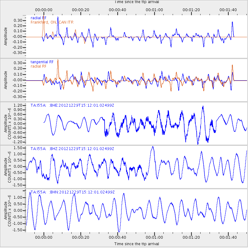
I55A Frankford, ON, CAN - Earthquake Result Viewer
*The percent match for this event was below the threshold and hence no stack was calculated.
| Earthquake location: |
Near East Coast Of Honshu, Japan |
| Earthquake latitude/longitude: |
38.7/142.0 |
| Earthquake time(UTC): |
2012/12/29 (364) 14:59:38 GMT |
| Earthquake Depth: |
56 km |
| Earthquake Magnitude: |
5.5 MW, 5.4 MW, 5.4 MB |
| Earthquake Catalog/Contributor: |
WHDF/NEIC |
|
| Network: |
TA USArray Transportable Network (new EarthScope stations) |
| Station: |
I55A Frankford, ON, CAN |
| Lat/Lon: |
44.22 N/77.68 W |
| Elevation: |
132 m |
|
| Distance: |
90.0 deg |
| Az: |
27.346 deg |
| Baz: |
330.025 deg |
| Ray Param: |
$rayparam |
*The percent match for this event was below the threshold and hence was not used in the summary stack. |
|
| Radial Match: |
50.188576 % |
| Radial Bump: |
318 |
| Transverse Match: |
41.61012 % |
| Transverse Bump: |
352 |
| SOD ConfigId: |
491031 |
| Insert Time: |
2013-04-10 04:43:31.780 +0000 |
| GWidth: |
2.5 |
| Max Bumps: |
400 |
| Tol: |
0.001 |
|
Signal To Noise
| Channel | StoN | STA | LTA |
| TA:I55A: :BHZ:20121229T15:12:01.02499Z | 1.8593725 | 9.165911E-7 | 4.929572E-7 |
| TA:I55A: :BHN:20121229T15:12:01.02499Z | 0.98749256 | 6.078487E-7 | 6.155476E-7 |
| TA:I55A: :BHE:20121229T15:12:01.02499Z | 1.2303057 | 4.2466775E-7 | 3.4517257E-7 |
| Arrivals |
| Ps | |
| PpPs | |
| PsPs/PpSs | |


