You are here: Home > Network List > TA - USArray Transportable Network (new EarthScope stations) Stations List
> Station E41A Kenton, MI, USA > Earthquake Result Viewer
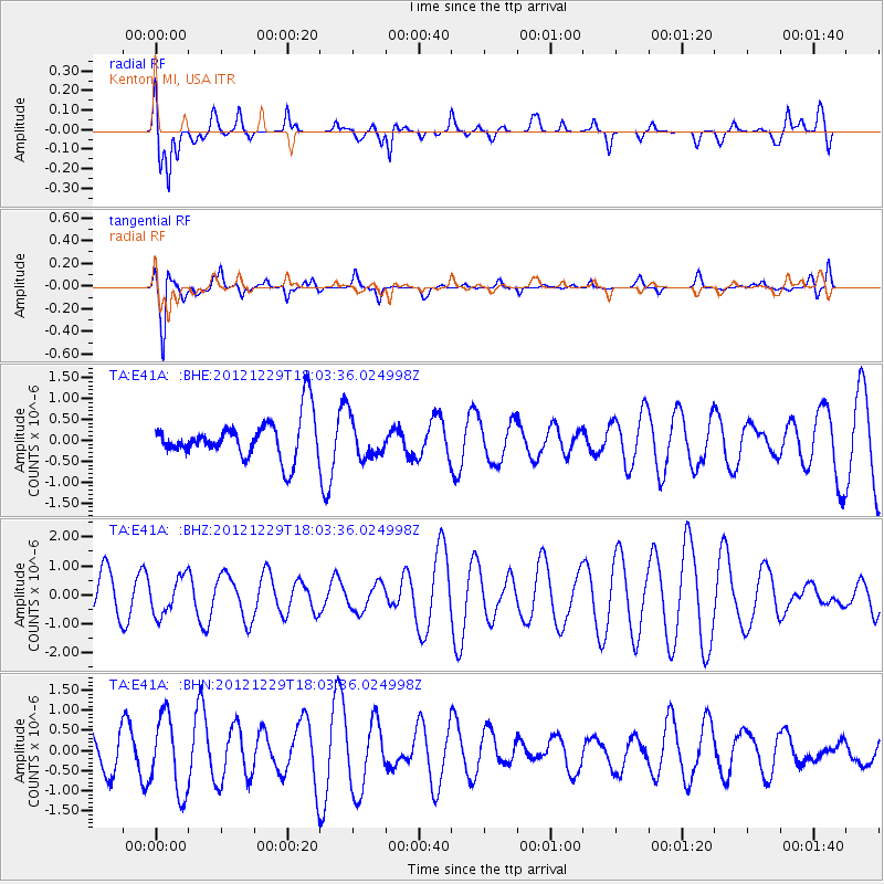
E41A Kenton, MI, USA - Earthquake Result Viewer
*The percent match for this event was below the threshold and hence no stack was calculated.
| Earthquake location: |
Hindu Kush Region, Afghanistan |
| Earthquake latitude/longitude: |
35.7/70.6 |
| Earthquake time(UTC): |
2012/12/29 (364) 17:50:52 GMT |
| Earthquake Depth: |
117 km |
| Earthquake Magnitude: |
5.6 MB, 5.5 MW, 5.6 MW |
| Earthquake Catalog/Contributor: |
WHDF/NEIC |
|
| Network: |
TA USArray Transportable Network (new EarthScope stations) |
| Station: |
E41A Kenton, MI, USA |
| Lat/Lon: |
46.46 N/88.96 W |
| Elevation: |
377 m |
|
| Distance: |
96.2 deg |
| Az: |
345.95 deg |
| Baz: |
16.608 deg |
| Ray Param: |
$rayparam |
*The percent match for this event was below the threshold and hence was not used in the summary stack. |
|
| Radial Match: |
48.113037 % |
| Radial Bump: |
400 |
| Transverse Match: |
76.51712 % |
| Transverse Bump: |
326 |
| SOD ConfigId: |
491031 |
| Insert Time: |
2013-04-10 04:49:24.665 +0000 |
| GWidth: |
2.5 |
| Max Bumps: |
400 |
| Tol: |
0.001 |
|
Signal To Noise
| Channel | StoN | STA | LTA |
| TA:E41A: :BHZ:20121229T18:03:36.024998Z | 1.00317 | 6.4178187E-7 | 6.3975386E-7 |
| TA:E41A: :BHN:20121229T18:03:36.024998Z | 2.940356 | 9.488285E-7 | 3.2269168E-7 |
| TA:E41A: :BHE:20121229T18:03:36.024998Z | 0.9426279 | 4.6133135E-7 | 4.8940984E-7 |
| Arrivals |
| Ps | |
| PpPs | |
| PsPs/PpSs | |


