You are here: Home > Network List > TA - USArray Transportable Network (new EarthScope stations) Stations List
> Station M51A Elyria, OH, USA > Earthquake Result Viewer
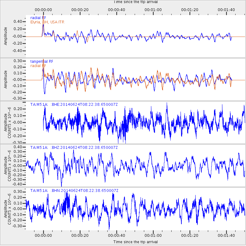
M51A Elyria, OH, USA - Earthquake Result Viewer
*The percent match for this event was below the threshold and hence no stack was calculated.
| Earthquake location: |
Rat Islands, Aleutian Islands |
| Earthquake latitude/longitude: |
52.2/176.6 |
| Earthquake time(UTC): |
2014/06/24 (175) 08:12:33 GMT |
| Earthquake Depth: |
23 km |
| Earthquake Magnitude: |
5.8 MW |
| Earthquake Catalog/Contributor: |
ISC/ISC |
|
| Network: |
TA USArray Transportable Network (new EarthScope stations) |
| Station: |
M51A Elyria, OH, USA |
| Lat/Lon: |
41.33 N/82.18 W |
| Elevation: |
239 m |
|
| Distance: |
64.7 deg |
| Az: |
54.813 deg |
| Baz: |
318.074 deg |
| Ray Param: |
$rayparam |
*The percent match for this event was below the threshold and hence was not used in the summary stack. |
|
| Radial Match: |
47.969822 % |
| Radial Bump: |
400 |
| Transverse Match: |
52.929245 % |
| Transverse Bump: |
400 |
| SOD ConfigId: |
3390531 |
| Insert Time: |
2019-04-12 12:45:14.699 +0000 |
| GWidth: |
2.5 |
| Max Bumps: |
400 |
| Tol: |
0.001 |
|
Signal To Noise
| Channel | StoN | STA | LTA |
| TA:M51A: :BHZ:20140624T08:22:38.650007Z | 2.4859788 | 1.7760804E-7 | 7.144391E-8 |
| TA:M51A: :BHN:20140624T08:22:38.650007Z | 1.3956733 | 1.0911863E-7 | 7.8183504E-8 |
| TA:M51A: :BHE:20140624T08:22:38.650007Z | 1.5142308 | 1.1139131E-7 | 7.3562965E-8 |
| Arrivals |
| Ps | |
| PpPs | |
| PsPs/PpSs | |


