You are here: Home > Network List > CN - Canadian National Seismograph Network Stations List
> Station SADO SADOWA, ON > Earthquake Result Viewer
SADO SADOWA, ON - Earthquake Result Viewer

| Earthquake location: |
Southeastern Alaska |
| Earthquake latitude/longitude: |
55.4/-134.7 |
| Earthquake time(UTC): |
2013/01/05 (005) 08:58:19 GMT |
| Earthquake Depth: |
10 km |
| Earthquake Magnitude: |
6.4 MB, 7.7 MS, 7.5 MW, 7.5 MW |
| Earthquake Catalog/Contributor: |
WHDF/NEIC |
|
| Network: |
CN Canadian National Seismograph Network |
| Station: |
SADO SADOWA, ON |
| Lat/Lon: |
44.77 N/79.14 W |
| Elevation: |
243 m |
|
| Distance: |
36.2 deg |
| Az: |
83.28 deg |
| Baz: |
307.302 deg |
| Ray Param: |
0.07678864 |
| Estimated Moho Depth: |
38.75 km |
| Estimated Crust Vp/Vs: |
1.76 |
| Assumed Crust Vp: |
6.577 km/s |
| Estimated Crust Vs: |
3.742 km/s |
| Estimated Crust Poisson's Ratio: |
0.26 |
|
| Radial Match: |
93.5049 % |
| Radial Bump: |
255 |
| Transverse Match: |
89.787315 % |
| Transverse Bump: |
400 |
| SOD ConfigId: |
492951 |
| Insert Time: |
2013-04-14 12:41:30.730 +0000 |
| GWidth: |
2.5 |
| Max Bumps: |
400 |
| Tol: |
0.001 |
|
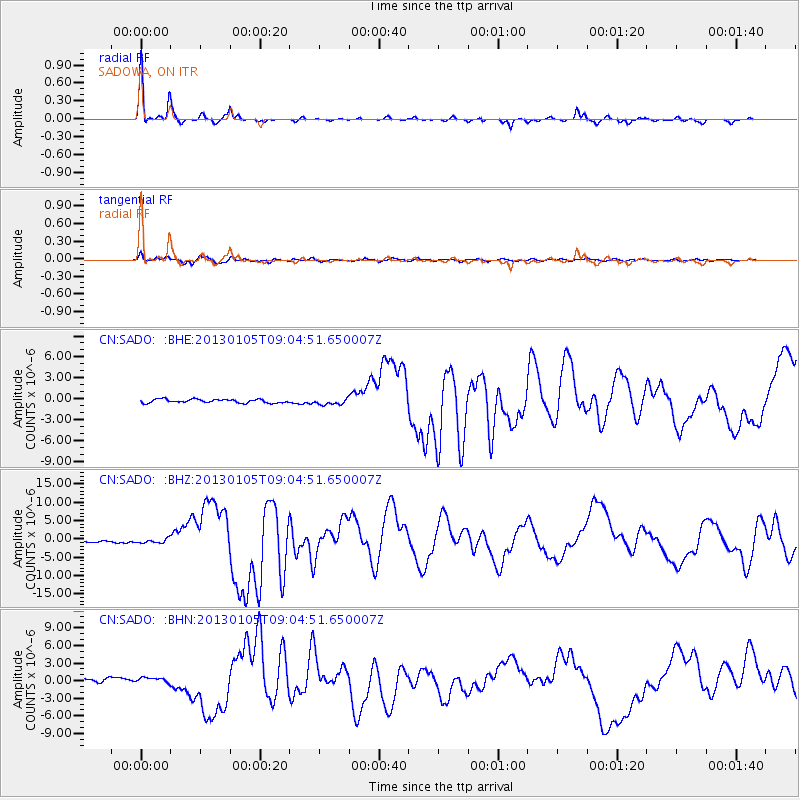
Signal To Noise
| Channel | StoN | STA | LTA |
| CN:SADO: :BHZ:20130105T09:04:51.650007Z | 1.6750902 | 6.211344E-7 | 3.7080653E-7 |
| CN:SADO: :BHN:20130105T09:04:51.650007Z | 1.6332543 | 4.3757242E-7 | 2.6791446E-7 |
| CN:SADO: :BHE:20130105T09:04:51.650007Z | 1.7849708 | 4.5142622E-7 | 2.52904E-7 |
| Arrivals |
| Ps | 4.8 SECOND |
| PpPs | 15 SECOND |
| PsPs/PpSs | 20 SECOND |


