You are here: Home > Network List > TA - USArray Transportable Network (new EarthScope stations) Stations List
> Station R11A Troy Canyon, Currant, NV, USA > Earthquake Result Viewer
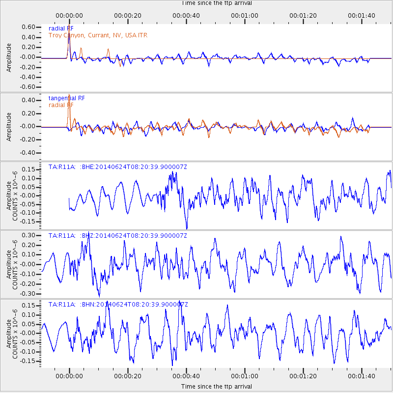
R11A Troy Canyon, Currant, NV, USA - Earthquake Result Viewer
*The percent match for this event was below the threshold and hence no stack was calculated.
| Earthquake location: |
Rat Islands, Aleutian Islands |
| Earthquake latitude/longitude: |
52.2/176.6 |
| Earthquake time(UTC): |
2014/06/24 (175) 08:12:33 GMT |
| Earthquake Depth: |
23 km |
| Earthquake Magnitude: |
5.8 MW |
| Earthquake Catalog/Contributor: |
ISC/ISC |
|
| Network: |
TA USArray Transportable Network (new EarthScope stations) |
| Station: |
R11A Troy Canyon, Currant, NV, USA |
| Lat/Lon: |
38.35 N/115.59 W |
| Elevation: |
1756 m |
|
| Distance: |
48.0 deg |
| Az: |
78.606 deg |
| Baz: |
309.859 deg |
| Ray Param: |
$rayparam |
*The percent match for this event was below the threshold and hence was not used in the summary stack. |
|
| Radial Match: |
73.7197 % |
| Radial Bump: |
400 |
| Transverse Match: |
50.214947 % |
| Transverse Bump: |
363 |
| SOD ConfigId: |
3390531 |
| Insert Time: |
2019-04-12 12:45:43.321 +0000 |
| GWidth: |
2.5 |
| Max Bumps: |
400 |
| Tol: |
0.001 |
|
Signal To Noise
| Channel | StoN | STA | LTA |
| TA:R11A: :BHZ:20140624T08:20:39.900007Z | 1.7447857 | 9.7501385E-8 | 5.5881582E-8 |
| TA:R11A: :BHN:20140624T08:20:39.900007Z | 1.2345297 | 5.0684907E-8 | 4.1056044E-8 |
| TA:R11A: :BHE:20140624T08:20:39.900007Z | 1.0440961 | 5.49468E-8 | 5.2626188E-8 |
| Arrivals |
| Ps | |
| PpPs | |
| PsPs/PpSs | |


