You are here: Home > Network List > IC - New China Digital Seismograph Network Stations List
> Station BJT Baijiatuan, Beijing, China > Earthquake Result Viewer
BJT Baijiatuan, Beijing, China - Earthquake Result Viewer
| Earthquake location: |
Southeastern Alaska |
| Earthquake latitude/longitude: |
55.4/-134.7 |
| Earthquake time(UTC): |
2013/01/05 (005) 08:58:19 GMT |
| Earthquake Depth: |
10 km |
| Earthquake Magnitude: |
6.4 MB, 7.7 MS, 7.5 MW, 7.5 MW |
| Earthquake Catalog/Contributor: |
WHDF/NEIC |
|
| Network: |
IC New China Digital Seismograph Network |
| Station: |
BJT Baijiatuan, Beijing, China |
| Lat/Lon: |
40.02 N/116.17 E |
| Elevation: |
197 m |
|
| Distance: |
67.5 deg |
| Az: |
308.29 deg |
| Baz: |
35.669 deg |
| Ray Param: |
0.056891568 |
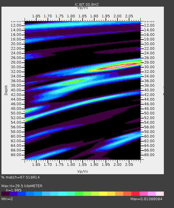
| Estimated Moho Depth: |
29.5 km |
| Estimated Crust Vp/Vs: |
2.00 |
| Assumed Crust Vp: |
6.464 km/s |
| Estimated Crust Vs: |
3.24 km/s |
| Estimated Crust Poisson's Ratio: |
0.33 |
|
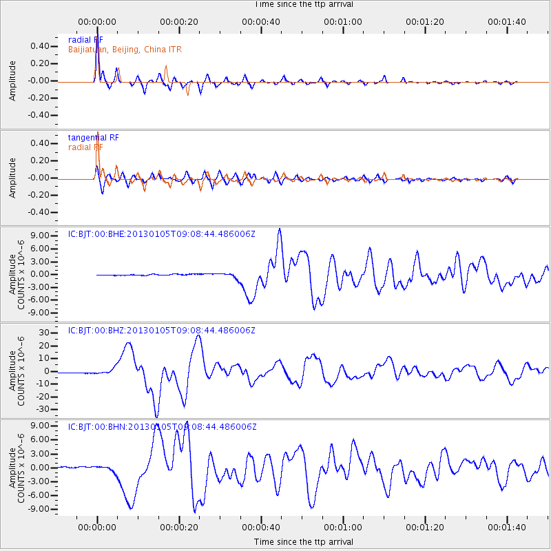
| Radial Match: |
97.516914 % |
| Radial Bump: |
308 |
| Transverse Match: |
89.65833 % |
| Transverse Bump: |
400 |
| SOD ConfigId: |
492951 |
| Insert Time: |
2013-04-14 12:42:29.712 +0000 |
| GWidth: |
2.5 |
| Max Bumps: |
400 |
| Tol: |
0.001 |
|
Signal To Noise
| Channel | StoN | STA | LTA |
| IC:BJT:00:BHZ:20130105T09:08:44.486006Z | 8.262962 | 2.5286154E-6 | 3.0601802E-7 |
| IC:BJT:00:BHN:20130105T09:08:44.486006Z | 4.4719296 | 6.557463E-7 | 1.4663611E-7 |
| IC:BJT:00:BHE:20130105T09:08:44.486006Z | 5.6790676 | 6.8036354E-7 | 1.1980197E-7 |
| Arrivals |
| Ps | 4.7 SECOND |
| PpPs | 13 SECOND |
| PsPs/PpSs | 18 SECOND |


