You are here: Home > Network List > IU - Global Seismograph Network (GSN - IRIS/USGS) Stations List
> Station KBL Kabul, Afghanistan > Earthquake Result Viewer
KBL Kabul, Afghanistan - Earthquake Result Viewer
| Earthquake location: |
Southeastern Alaska |
| Earthquake latitude/longitude: |
55.4/-134.7 |
| Earthquake time(UTC): |
2013/01/05 (005) 08:58:19 GMT |
| Earthquake Depth: |
10 km |
| Earthquake Magnitude: |
6.4 MB, 7.7 MS, 7.5 MW, 7.5 MW |
| Earthquake Catalog/Contributor: |
WHDF/NEIC |
|
| Network: |
IU Global Seismograph Network (GSN - IRIS/USGS) |
| Station: |
KBL Kabul, Afghanistan |
| Lat/Lon: |
34.54 N/69.04 E |
| Elevation: |
1920 m |
|
| Distance: |
88.2 deg |
| Az: |
340.615 deg |
| Baz: |
13.262 deg |
| Ray Param: |
0.042800233 |
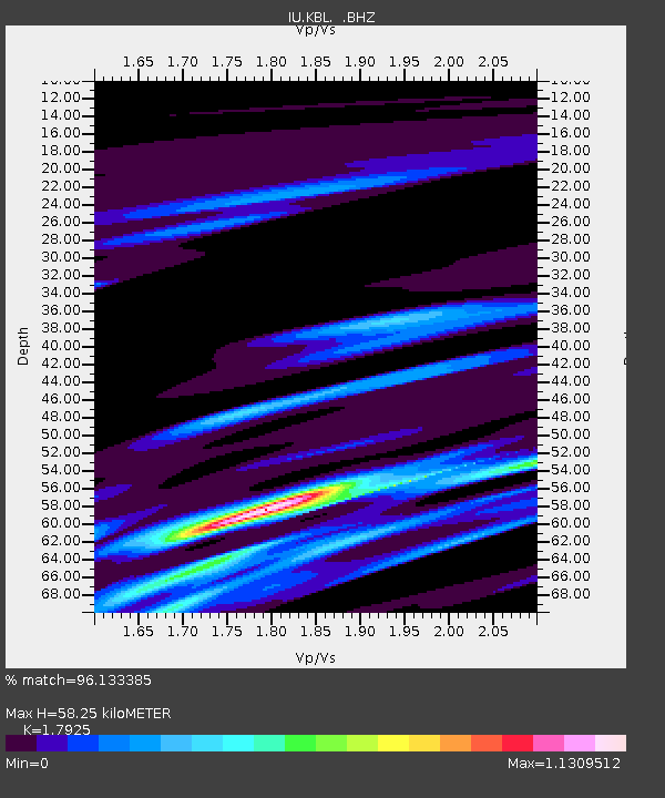
| Estimated Moho Depth: |
58.25 km |
| Estimated Crust Vp/Vs: |
1.79 |
| Assumed Crust Vp: |
6.641 km/s |
| Estimated Crust Vs: |
3.705 km/s |
| Estimated Crust Poisson's Ratio: |
0.27 |
|
| Radial Match: |
96.133385 % |
| Radial Bump: |
400 |
| Transverse Match: |
85.808464 % |
| Transverse Bump: |
400 |
| SOD ConfigId: |
492951 |
| Insert Time: |
2013-04-14 12:43:10.941 +0000 |
| GWidth: |
2.5 |
| Max Bumps: |
400 |
| Tol: |
0.001 |
|
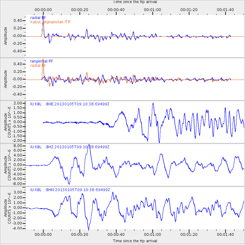
Signal To Noise
| Channel | StoN | STA | LTA |
| IU:KBL: :BHZ:20130105T09:10:38.69499Z | 8.25203 | 6.805046E-7 | 8.2465114E-8 |
| IU:KBL: :BHN:20130105T09:10:38.69499Z | 4.998293 | 2.1647551E-7 | 4.330989E-8 |
| IU:KBL: :BHE:20130105T09:10:38.69499Z | 3.0886183 | 1.1476133E-7 | 3.7156205E-8 |
| Arrivals |
| Ps | 7.1 SECOND |
| PpPs | 24 SECOND |
| PsPs/PpSs | 31 SECOND |


