You are here: Home > Network List > NM - Cooperative New Madrid Seismic Network Stations List
> Station UTMT Martin, TN > Earthquake Result Viewer
UTMT Martin, TN - Earthquake Result Viewer
| Earthquake location: |
Southeastern Alaska |
| Earthquake latitude/longitude: |
55.4/-134.7 |
| Earthquake time(UTC): |
2013/01/05 (005) 08:58:19 GMT |
| Earthquake Depth: |
10 km |
| Earthquake Magnitude: |
6.4 MB, 7.7 MS, 7.5 MW, 7.5 MW |
| Earthquake Catalog/Contributor: |
WHDF/NEIC |
|
| Network: |
NM Cooperative New Madrid Seismic Network |
| Station: |
UTMT Martin, TN |
| Lat/Lon: |
36.35 N/88.86 W |
| Elevation: |
110 m |
|
| Distance: |
36.3 deg |
| Az: |
102.251 deg |
| Baz: |
316.321 deg |
| Ray Param: |
0.07675094 |
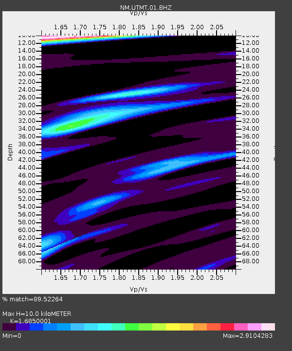
| Estimated Moho Depth: |
10.0 km |
| Estimated Crust Vp/Vs: |
1.69 |
| Assumed Crust Vp: |
6.444 km/s |
| Estimated Crust Vs: |
3.824 km/s |
| Estimated Crust Poisson's Ratio: |
0.23 |
|
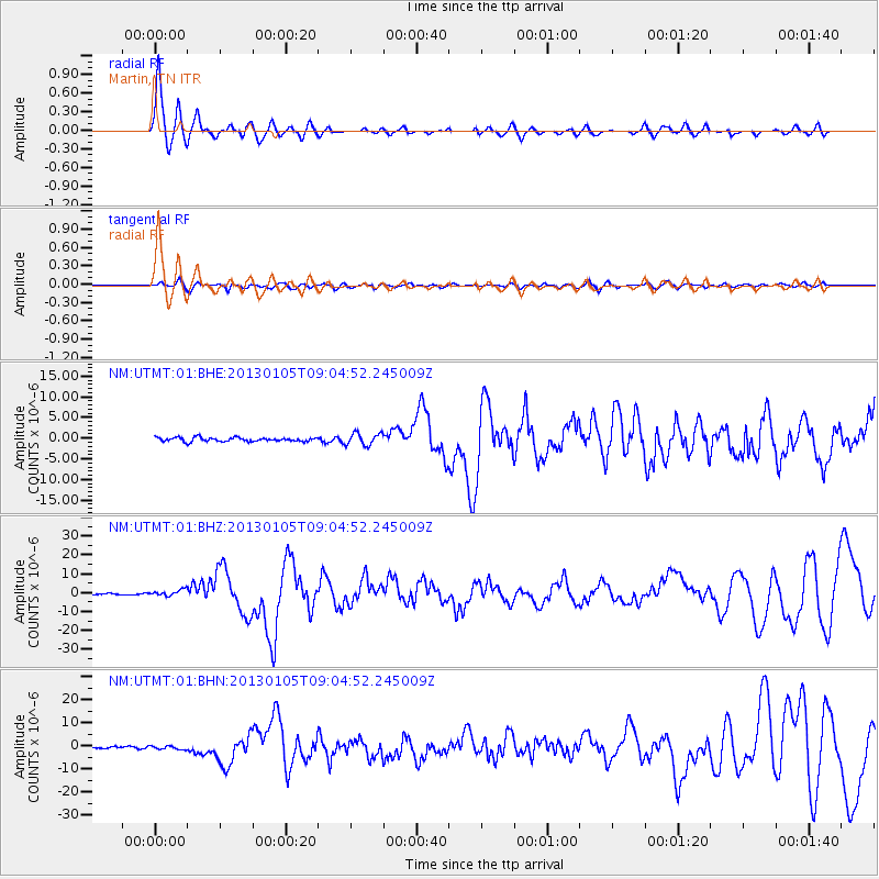
| Radial Match: |
89.52264 % |
| Radial Bump: |
396 |
| Transverse Match: |
70.24342 % |
| Transverse Bump: |
400 |
| SOD ConfigId: |
492951 |
| Insert Time: |
2013-04-14 12:47:35.043 +0000 |
| GWidth: |
2.5 |
| Max Bumps: |
400 |
| Tol: |
0.001 |
|
Signal To Noise
| Channel | StoN | STA | LTA |
| NM:UTMT:01:BHZ:20130105T09:04:52.245009Z | 3.761587 | 1.6344375E-6 | 4.3450743E-7 |
| NM:UTMT:01:BHN:20130105T09:04:52.245009Z | 1.2233716 | 7.412665E-7 | 6.059209E-7 |
| NM:UTMT:01:BHE:20130105T09:04:52.245009Z | 3.064699 | 1.4432933E-6 | 4.709413E-7 |
| Arrivals |
| Ps | 1.2 SECOND |
| PpPs | 3.8 SECOND |
| PsPs/PpSs | 5.0 SECOND |


