You are here: Home > Network List > TA - USArray Transportable Network (new EarthScope stations) Stations List
> Station 348A Jackson, AL, USA > Earthquake Result Viewer
348A Jackson, AL, USA - Earthquake Result Viewer
| Earthquake location: |
Southeastern Alaska |
| Earthquake latitude/longitude: |
55.4/-134.7 |
| Earthquake time(UTC): |
2013/01/05 (005) 08:58:19 GMT |
| Earthquake Depth: |
10 km |
| Earthquake Magnitude: |
6.4 MB, 7.7 MS, 7.5 MW, 7.5 MW |
| Earthquake Catalog/Contributor: |
WHDF/NEIC |
|
| Network: |
TA USArray Transportable Network (new EarthScope stations) |
| Station: |
348A Jackson, AL, USA |
| Lat/Lon: |
31.41 N/87.90 W |
| Elevation: |
57 m |
|
| Distance: |
40.5 deg |
| Az: |
106.564 deg |
| Baz: |
320.237 deg |
| Ray Param: |
0.07435461 |
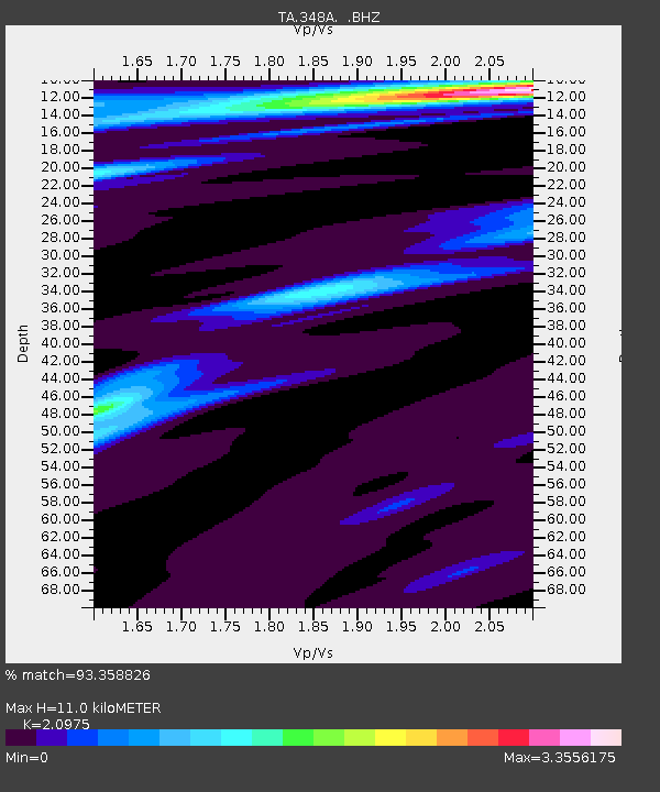
| Estimated Moho Depth: |
11.0 km |
| Estimated Crust Vp/Vs: |
2.10 |
| Assumed Crust Vp: |
6.187 km/s |
| Estimated Crust Vs: |
2.95 km/s |
| Estimated Crust Poisson's Ratio: |
0.35 |
|
| Radial Match: |
93.358826 % |
| Radial Bump: |
232 |
| Transverse Match: |
71.12734 % |
| Transverse Bump: |
380 |
| SOD ConfigId: |
492951 |
| Insert Time: |
2013-04-14 12:52:09.458 +0000 |
| GWidth: |
2.5 |
| Max Bumps: |
400 |
| Tol: |
0.001 |
|
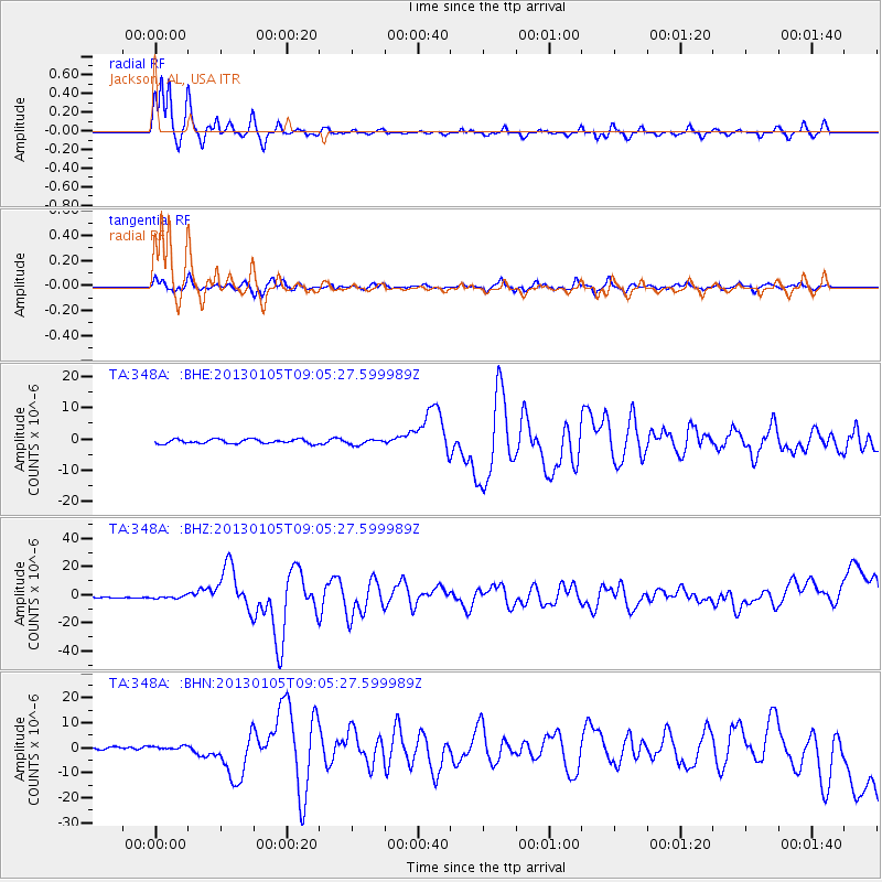
Signal To Noise
| Channel | StoN | STA | LTA |
| TA:348A: :BHZ:20130105T09:05:27.599989Z | 3.3255403 | 9.571444E-7 | 2.878162E-7 |
| TA:348A: :BHN:20130105T09:05:27.599989Z | 1.2757555 | 6.340524E-7 | 4.970015E-7 |
| TA:348A: :BHE:20130105T09:05:27.599989Z | 1.1944923 | 8.2589867E-7 | 6.9142226E-7 |
| Arrivals |
| Ps | 2.1 SECOND |
| PpPs | 5.2 SECOND |
| PsPs/PpSs | 7.3 SECOND |


