You are here: Home > Network List > TA - USArray Transportable Network (new EarthScope stations) Stations List
> Station 147A Livingston, AL, USA > Earthquake Result Viewer
147A Livingston, AL, USA - Earthquake Result Viewer
| Earthquake location: |
Southeastern Alaska |
| Earthquake latitude/longitude: |
55.4/-134.7 |
| Earthquake time(UTC): |
2013/01/05 (005) 08:58:19 GMT |
| Earthquake Depth: |
10 km |
| Earthquake Magnitude: |
6.4 MB, 7.7 MS, 7.5 MW, 7.5 MW |
| Earthquake Catalog/Contributor: |
WHDF/NEIC |
|
| Network: |
TA USArray Transportable Network (new EarthScope stations) |
| Station: |
147A Livingston, AL, USA |
| Lat/Lon: |
32.67 N/88.27 W |
| Elevation: |
57 m |
|
| Distance: |
39.4 deg |
| Az: |
105.672 deg |
| Baz: |
319.359 deg |
| Ray Param: |
0.07503106 |
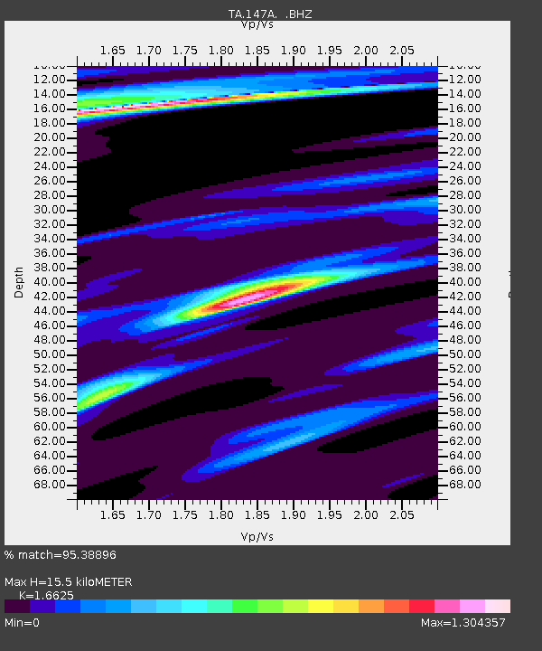
| Estimated Moho Depth: |
15.5 km |
| Estimated Crust Vp/Vs: |
1.66 |
| Assumed Crust Vp: |
6.201 km/s |
| Estimated Crust Vs: |
3.73 km/s |
| Estimated Crust Poisson's Ratio: |
0.22 |
|
| Radial Match: |
95.38896 % |
| Radial Bump: |
210 |
| Transverse Match: |
34.812077 % |
| Transverse Bump: |
400 |
| SOD ConfigId: |
492951 |
| Insert Time: |
2013-04-14 12:53:21.371 +0000 |
| GWidth: |
2.5 |
| Max Bumps: |
400 |
| Tol: |
0.001 |
|

Signal To Noise
| Channel | StoN | STA | LTA |
| TA:147A: :BHZ:20130105T09:05:17.949995Z | 2.893947 | 1.1695961E-6 | 4.041526E-7 |
| TA:147A: :BHN:20130105T09:05:17.949995Z | 2.3333528 | 7.567393E-7 | 3.2431416E-7 |
| TA:147A: :BHE:20130105T09:05:17.949995Z | 1.9930218 | 7.656469E-7 | 3.8416385E-7 |
| Arrivals |
| Ps | 1.8 SECOND |
| PpPs | 6.2 SECOND |
| PsPs/PpSs | 8.0 SECOND |


