You are here: Home > Network List > TA - USArray Transportable Network (new EarthScope stations) Stations List
> Station Y47A UCPARC, Winfield, AL, USA > Earthquake Result Viewer
Y47A UCPARC, Winfield, AL, USA - Earthquake Result Viewer
| Earthquake location: |
Southeastern Alaska |
| Earthquake latitude/longitude: |
55.4/-134.7 |
| Earthquake time(UTC): |
2013/01/05 (005) 08:58:19 GMT |
| Earthquake Depth: |
10 km |
| Earthquake Magnitude: |
6.4 MB, 7.7 MS, 7.5 MW, 7.5 MW |
| Earthquake Catalog/Contributor: |
WHDF/NEIC |
|
| Network: |
TA USArray Transportable Network (new EarthScope stations) |
| Station: |
Y47A UCPARC, Winfield, AL, USA |
| Lat/Lon: |
33.90 N/87.85 W |
| Elevation: |
160 m |
|
| Distance: |
38.7 deg |
| Az: |
103.968 deg |
| Baz: |
318.265 deg |
| Ray Param: |
0.0754295 |
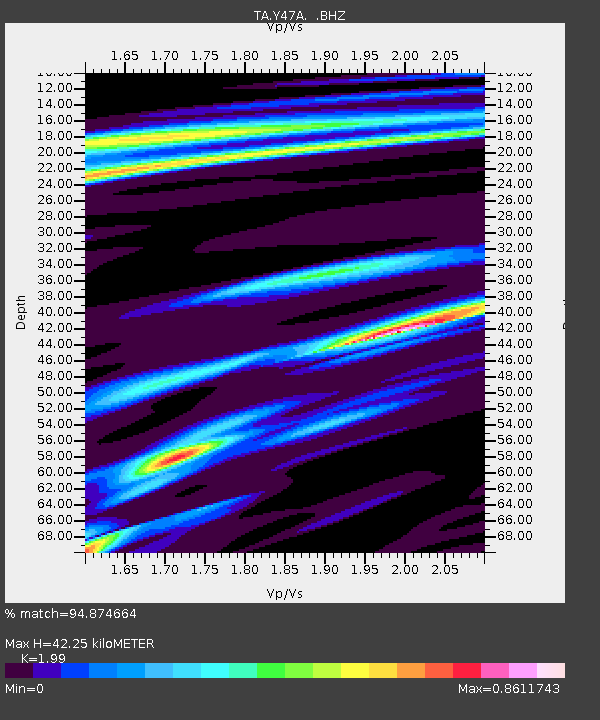
| Estimated Moho Depth: |
42.25 km |
| Estimated Crust Vp/Vs: |
1.99 |
| Assumed Crust Vp: |
6.565 km/s |
| Estimated Crust Vs: |
3.299 km/s |
| Estimated Crust Poisson's Ratio: |
0.33 |
|
| Radial Match: |
94.874664 % |
| Radial Bump: |
302 |
| Transverse Match: |
77.19115 % |
| Transverse Bump: |
386 |
| SOD ConfigId: |
492951 |
| Insert Time: |
2013-04-14 12:53:32.016 +0000 |
| GWidth: |
2.5 |
| Max Bumps: |
400 |
| Tol: |
0.001 |
|

Signal To Noise
| Channel | StoN | STA | LTA |
| TA:Y47A: :BHZ:20130105T09:05:12.175001Z | 3.1492596 | 1.1385612E-6 | 3.6153295E-7 |
| TA:Y47A: :BHN:20130105T09:05:12.175001Z | 2.2350612 | 6.0924185E-7 | 2.7258395E-7 |
| TA:Y47A: :BHE:20130105T09:05:12.175001Z | 2.7469962 | 5.1260605E-7 | 1.8660603E-7 |
| Arrivals |
| Ps | 6.8 SECOND |
| PpPs | 18 SECOND |
| PsPs/PpSs | 25 SECOND |


