You are here: Home > Network List > TA - USArray Transportable Network (new EarthScope stations) Stations List
> Station Y45A Yeager Farm, Coffeeville, MS, USA > Earthquake Result Viewer
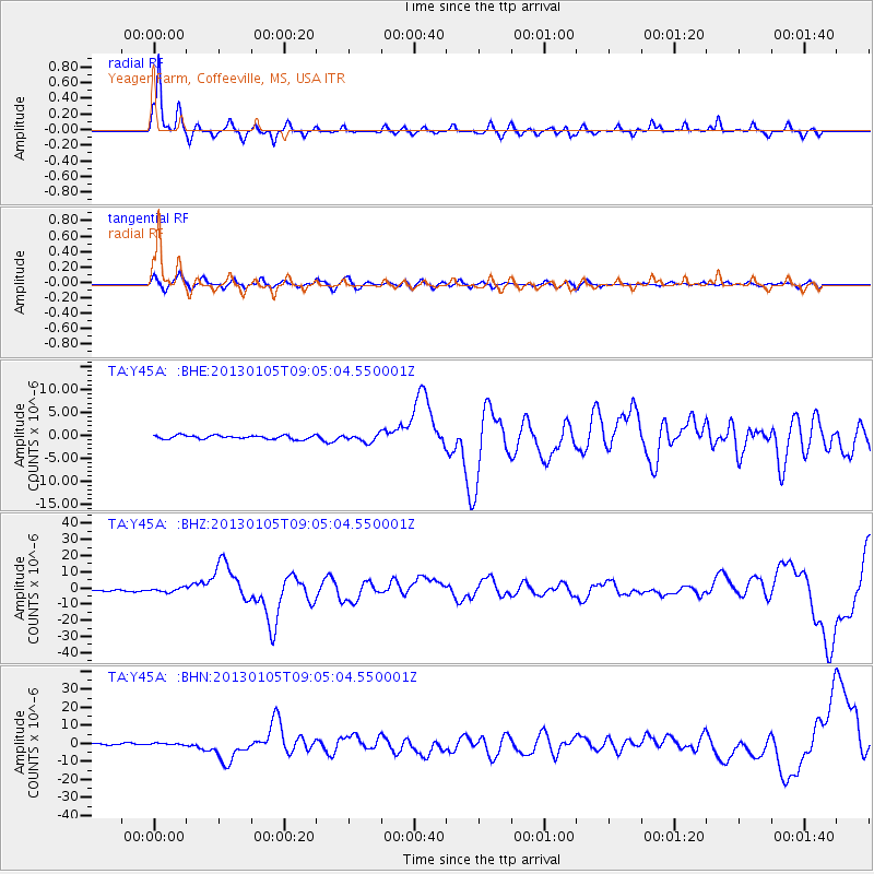
Y45A Yeager Farm, Coffeeville, MS, USA - Earthquake Result Viewer
| Earthquake location: |
Southeastern Alaska |
| Earthquake latitude/longitude: |
55.4/-134.7 |
| Earthquake time(UTC): |
2013/01/05 (005) 08:58:19 GMT |
| Earthquake Depth: |
10 km |
| Earthquake Magnitude: |
6.4 MB, 7.7 MS, 7.5 MW, 7.5 MW |
| Earthquake Catalog/Contributor: |
WHDF/NEIC |
|
| Network: |
TA USArray Transportable Network (new EarthScope stations) |
| Station: |
Y45A Yeager Farm, Coffeeville, MS, USA |
| Lat/Lon: |
33.87 N/89.54 W |
| Elevation: |
106 m |
|
| Distance: |
37.8 deg |
| Az: |
105.713 deg |
| Baz: |
318.696 deg |
| Ray Param: |
0.07595416 |
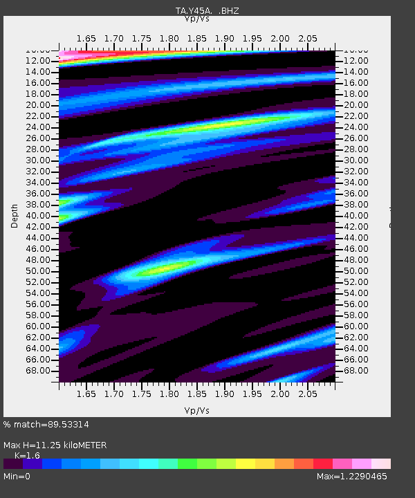
| Estimated Moho Depth: |
11.25 km |
| Estimated Crust Vp/Vs: |
1.60 |
| Assumed Crust Vp: |
6.201 km/s |
| Estimated Crust Vs: |
3.876 km/s |
| Estimated Crust Poisson's Ratio: |
0.18 |
|
| Radial Match: |
89.53314 % |
| Radial Bump: |
322 |
| Transverse Match: |
66.34789 % |
| Transverse Bump: |
400 |
| SOD ConfigId: |
492951 |
| Insert Time: |
2013-04-14 12:54:12.867 +0000 |
| GWidth: |
2.5 |
| Max Bumps: |
400 |
| Tol: |
0.001 |
|
Signal To Noise
| Channel | StoN | STA | LTA |
| TA:Y45A: :BHZ:20130105T09:05:04.550001Z | 2.626801 | 1.2550855E-6 | 4.7780003E-7 |
| TA:Y45A: :BHN:20130105T09:05:04.550001Z | 0.94559556 | 6.2377705E-7 | 6.5966583E-7 |
| TA:Y45A: :BHE:20130105T09:05:04.550001Z | 2.1363823 | 8.500992E-7 | 3.979153E-7 |
| Arrivals |
| Ps | 1.2 SECOND |
| PpPs | 4.4 SECOND |
| PsPs/PpSs | 5.5 SECOND |


