You are here: Home > Network List > TA - USArray Transportable Network (new EarthScope stations) Stations List
> Station Z43A Armstrong Family, Eudora, AR, USA > Earthquake Result Viewer
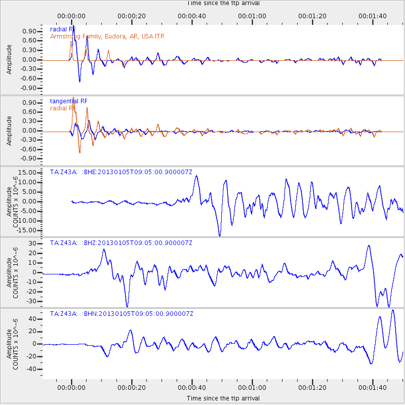
Z43A Armstrong Family, Eudora, AR, USA - Earthquake Result Viewer
| Earthquake location: |
Southeastern Alaska |
| Earthquake latitude/longitude: |
55.4/-134.7 |
| Earthquake time(UTC): |
2013/01/05 (005) 08:58:19 GMT |
| Earthquake Depth: |
10 km |
| Earthquake Magnitude: |
6.4 MB, 7.7 MS, 7.5 MW, 7.5 MW |
| Earthquake Catalog/Contributor: |
WHDF/NEIC |
|
| Network: |
TA USArray Transportable Network (new EarthScope stations) |
| Station: |
Z43A Armstrong Family, Eudora, AR, USA |
| Lat/Lon: |
33.21 N/91.24 W |
| Elevation: |
39 m |
|
| Distance: |
37.3 deg |
| Az: |
108.179 deg |
| Baz: |
319.716 deg |
| Ray Param: |
0.07619614 |
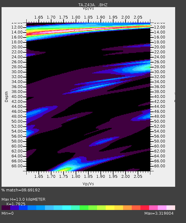
| Estimated Moho Depth: |
13.0 km |
| Estimated Crust Vp/Vs: |
1.79 |
| Assumed Crust Vp: |
6.201 km/s |
| Estimated Crust Vs: |
3.46 km/s |
| Estimated Crust Poisson's Ratio: |
0.27 |
|
| Radial Match: |
89.69192 % |
| Radial Bump: |
277 |
| Transverse Match: |
83.06419 % |
| Transverse Bump: |
333 |
| SOD ConfigId: |
492951 |
| Insert Time: |
2013-04-14 12:54:35.069 +0000 |
| GWidth: |
2.5 |
| Max Bumps: |
400 |
| Tol: |
0.001 |
|
Signal To Noise
| Channel | StoN | STA | LTA |
| TA:Z43A: :BHZ:20130105T09:05:00.900007Z | 3.1736863 | 1.1135005E-6 | 3.5085398E-7 |
| TA:Z43A: :BHN:20130105T09:05:00.900007Z | 2.243349 | 9.19879E-7 | 4.1004722E-7 |
| TA:Z43A: :BHE:20130105T09:05:00.900007Z | 1.9589025 | 8.8542043E-7 | 4.519982E-7 |
| Arrivals |
| Ps | 1.8 SECOND |
| PpPs | 5.5 SECOND |
| PsPs/PpSs | 7.2 SECOND |


