You are here: Home > Network List > TA - USArray Transportable Network (new EarthScope stations) Stations List
> Station Y41A Eaglette Bearden, AR, USA > Earthquake Result Viewer
Y41A Eaglette Bearden, AR, USA - Earthquake Result Viewer

| Earthquake location: |
Southeastern Alaska |
| Earthquake latitude/longitude: |
55.4/-134.7 |
| Earthquake time(UTC): |
2013/01/05 (005) 08:58:19 GMT |
| Earthquake Depth: |
10 km |
| Earthquake Magnitude: |
6.4 MB, 7.7 MS, 7.5 MW, 7.5 MW |
| Earthquake Catalog/Contributor: |
WHDF/NEIC |
|
| Network: |
TA USArray Transportable Network (new EarthScope stations) |
| Station: |
Y41A Eaglette Bearden, AR, USA |
| Lat/Lon: |
33.88 N/92.61 W |
| Elevation: |
99 m |
|
| Distance: |
36.1 deg |
| Az: |
108.91 deg |
| Baz: |
319.55 deg |
| Ray Param: |
0.07687664 |
| Estimated Moho Depth: |
28.75 km |
| Estimated Crust Vp/Vs: |
1.86 |
| Assumed Crust Vp: |
6.245 km/s |
| Estimated Crust Vs: |
3.353 km/s |
| Estimated Crust Poisson's Ratio: |
0.30 |
|
| Radial Match: |
92.755295 % |
| Radial Bump: |
368 |
| Transverse Match: |
81.951775 % |
| Transverse Bump: |
387 |
| SOD ConfigId: |
492951 |
| Insert Time: |
2013-04-14 12:54:46.006 +0000 |
| GWidth: |
2.5 |
| Max Bumps: |
400 |
| Tol: |
0.001 |
|
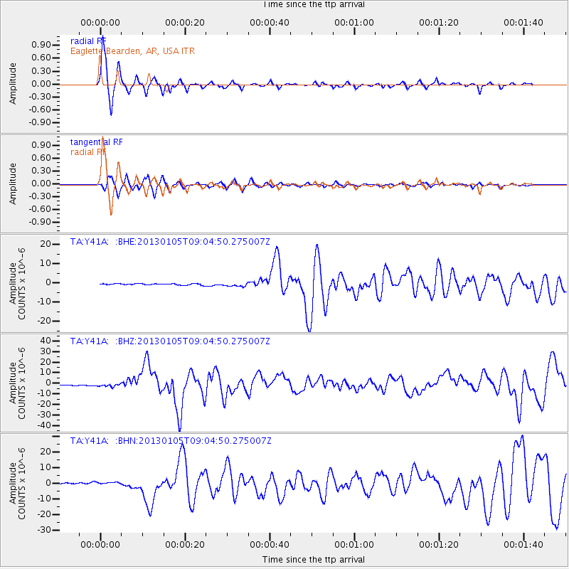
Signal To Noise
| Channel | StoN | STA | LTA |
| TA:Y41A: :BHZ:20130105T09:04:50.275007Z | 4.0296535 | 1.3907431E-6 | 3.4512723E-7 |
| TA:Y41A: :BHN:20130105T09:04:50.275007Z | 2.002663 | 7.0385977E-7 | 3.5146192E-7 |
| TA:Y41A: :BHE:20130105T09:04:50.275007Z | 2.6800106 | 9.3311763E-7 | 3.4817683E-7 |
| Arrivals |
| Ps | 4.2 SECOND |
| PpPs | 12 SECOND |
| PsPs/PpSs | 17 SECOND |


