You are here: Home > Network List > TA - USArray Transportable Network (new EarthScope stations) Stations List
> Station X45A UM Field Station, Abbeville, MS, USA > Earthquake Result Viewer
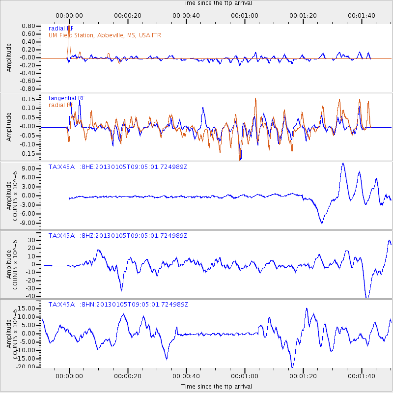
X45A UM Field Station, Abbeville, MS, USA - Earthquake Result Viewer
*The percent match for this event was below the threshold and hence no stack was calculated.
| Earthquake location: |
Southeastern Alaska |
| Earthquake latitude/longitude: |
55.4/-134.7 |
| Earthquake time(UTC): |
2013/01/05 (005) 08:58:19 GMT |
| Earthquake Depth: |
10 km |
| Earthquake Magnitude: |
6.4 MB, 7.7 MS, 7.5 MW, 7.5 MW |
| Earthquake Catalog/Contributor: |
WHDF/NEIC |
|
| Network: |
TA USArray Transportable Network (new EarthScope stations) |
| Station: |
X45A UM Field Station, Abbeville, MS, USA |
| Lat/Lon: |
34.42 N/89.39 W |
| Elevation: |
142 m |
|
| Distance: |
37.4 deg |
| Az: |
104.954 deg |
| Baz: |
318.179 deg |
| Ray Param: |
$rayparam |
*The percent match for this event was below the threshold and hence was not used in the summary stack. |
|
| Radial Match: |
41.44529 % |
| Radial Bump: |
400 |
| Transverse Match: |
43.046394 % |
| Transverse Bump: |
399 |
| SOD ConfigId: |
492951 |
| Insert Time: |
2013-04-14 12:56:11.078 +0000 |
| GWidth: |
2.5 |
| Max Bumps: |
400 |
| Tol: |
0.001 |
|
Signal To Noise
| Channel | StoN | STA | LTA |
| TA:X45A: :BHZ:20130105T09:05:01.724989Z | 3.2244508 | 1.0846695E-6 | 3.3638892E-7 |
| TA:X45A: :BHN:20130105T09:05:01.724989Z | 0.4364814 | 2.0903317E-6 | 4.789051E-6 |
| TA:X45A: :BHE:20130105T09:05:01.724989Z | 1.1417923 | 2.073945E-7 | 1.8163944E-7 |
| Arrivals |
| Ps | |
| PpPs | |
| PsPs/PpSs | |


