You are here: Home > Network List > TA - USArray Transportable Network (new EarthScope stations) Stations List
> Station Q43A New Douglas, IL, USA > Earthquake Result Viewer
Q43A New Douglas, IL, USA - Earthquake Result Viewer
| Earthquake location: |
Southeastern Alaska |
| Earthquake latitude/longitude: |
55.4/-134.7 |
| Earthquake time(UTC): |
2013/01/05 (005) 08:58:19 GMT |
| Earthquake Depth: |
10 km |
| Earthquake Magnitude: |
6.4 MB, 7.7 MS, 7.5 MW, 7.5 MW |
| Earthquake Catalog/Contributor: |
WHDF/NEIC |
|
| Network: |
TA USArray Transportable Network (new EarthScope stations) |
| Station: |
Q43A New Douglas, IL, USA |
| Lat/Lon: |
38.94 N/89.70 W |
| Elevation: |
202 m |
|
| Distance: |
34.0 deg |
| Az: |
99.896 deg |
| Baz: |
313.888 deg |
| Ray Param: |
0.07794514 |
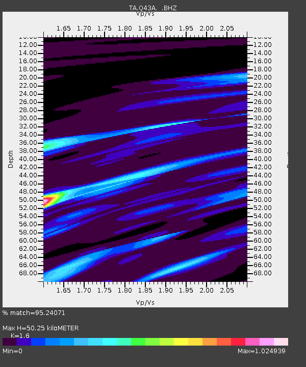
| Estimated Moho Depth: |
50.25 km |
| Estimated Crust Vp/Vs: |
1.60 |
| Assumed Crust Vp: |
6.444 km/s |
| Estimated Crust Vs: |
4.027 km/s |
| Estimated Crust Poisson's Ratio: |
0.18 |
|
| Radial Match: |
95.24071 % |
| Radial Bump: |
253 |
| Transverse Match: |
90.44696 % |
| Transverse Bump: |
400 |
| SOD ConfigId: |
492951 |
| Insert Time: |
2013-04-14 12:57:12.314 +0000 |
| GWidth: |
2.5 |
| Max Bumps: |
400 |
| Tol: |
0.001 |
|
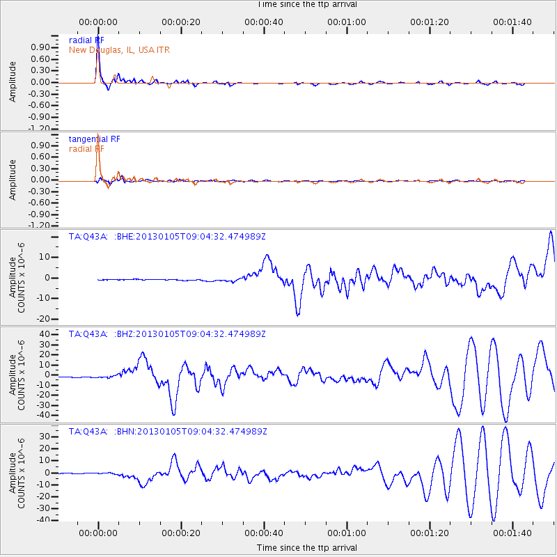
Signal To Noise
| Channel | StoN | STA | LTA |
| TA:Q43A: :BHZ:20130105T09:04:32.474989Z | 2.3806367 | 1.1343764E-6 | 4.765012E-7 |
| TA:Q43A: :BHN:20130105T09:04:32.474989Z | 1.9687576 | 6.158755E-7 | 3.1282443E-7 |
| TA:Q43A: :BHE:20130105T09:04:32.474989Z | 3.5822 | 6.508024E-7 | 1.8167674E-7 |
| Arrivals |
| Ps | 5.1 SECOND |
| PpPs | 19 SECOND |
| PsPs/PpSs | 24 SECOND |


