You are here: Home > Network List > TA - USArray Transportable Network (new EarthScope stations) Stations List
> Station U41A Viola, AR, USA > Earthquake Result Viewer
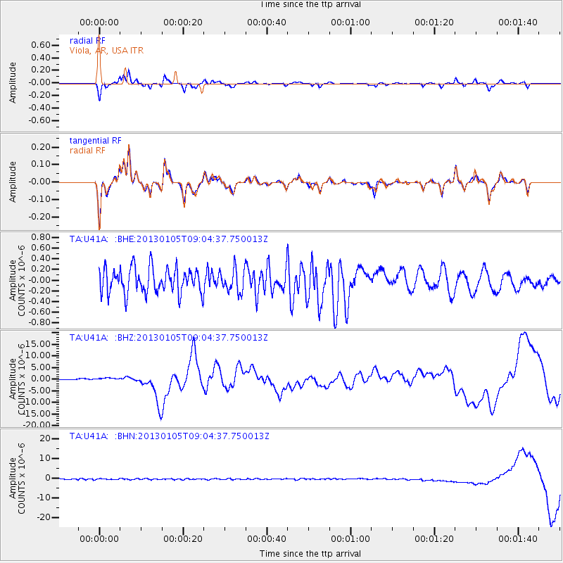
U41A Viola, AR, USA - Earthquake Result Viewer
*The percent match for this event was below the threshold and hence no stack was calculated.
| Earthquake location: |
Southeastern Alaska |
| Earthquake latitude/longitude: |
55.4/-134.7 |
| Earthquake time(UTC): |
2013/01/05 (005) 08:58:19 GMT |
| Earthquake Depth: |
10 km |
| Earthquake Magnitude: |
6.4 MB, 7.7 MS, 7.5 MW, 7.5 MW |
| Earthquake Catalog/Contributor: |
WHDF/NEIC |
|
| Network: |
TA USArray Transportable Network (new EarthScope stations) |
| Station: |
U41A Viola, AR, USA |
| Lat/Lon: |
36.34 N/91.92 W |
| Elevation: |
300 m |
|
| Distance: |
34.6 deg |
| Az: |
105.352 deg |
| Baz: |
317.044 deg |
| Ray Param: |
$rayparam |
*The percent match for this event was below the threshold and hence was not used in the summary stack. |
|
| Radial Match: |
78.82332 % |
| Radial Bump: |
315 |
| Transverse Match: |
78.4482 % |
| Transverse Bump: |
308 |
| SOD ConfigId: |
492951 |
| Insert Time: |
2013-04-14 12:59:24.727 +0000 |
| GWidth: |
2.5 |
| Max Bumps: |
400 |
| Tol: |
0.001 |
|
Signal To Noise
| Channel | StoN | STA | LTA |
| TA:U41A: :BHZ:20130105T09:04:37.750013Z | 2.8716202 | 5.755808E-7 | 2.0043765E-7 |
| TA:U41A: :BHN:20130105T09:04:37.750013Z | 0.75953895 | 2.374299E-7 | 3.1259742E-7 |
| TA:U41A: :BHE:20130105T09:04:37.750013Z | 0.9321252 | 2.150867E-7 | 2.3074871E-7 |
| Arrivals |
| Ps | |
| PpPs | |
| PsPs/PpSs | |


