You are here: Home > Network List > TA - USArray Transportable Network (new EarthScope stations) Stations List
> Station R41A Rosebud, MO, USA > Earthquake Result Viewer
R41A Rosebud, MO, USA - Earthquake Result Viewer

| Earthquake location: |
Southeastern Alaska |
| Earthquake latitude/longitude: |
55.4/-134.7 |
| Earthquake time(UTC): |
2013/01/05 (005) 08:58:19 GMT |
| Earthquake Depth: |
10 km |
| Earthquake Magnitude: |
6.4 MB, 7.7 MS, 7.5 MW, 7.5 MW |
| Earthquake Catalog/Contributor: |
WHDF/NEIC |
|
| Network: |
TA USArray Transportable Network (new EarthScope stations) |
| Station: |
R41A Rosebud, MO, USA |
| Lat/Lon: |
38.30 N/91.38 W |
| Elevation: |
257 m |
|
| Distance: |
33.5 deg |
| Az: |
102.379 deg |
| Baz: |
314.908 deg |
| Ray Param: |
0.07817131 |
| Estimated Moho Depth: |
44.5 km |
| Estimated Crust Vp/Vs: |
1.82 |
| Assumed Crust Vp: |
6.498 km/s |
| Estimated Crust Vs: |
3.575 km/s |
| Estimated Crust Poisson's Ratio: |
0.28 |
|
| Radial Match: |
94.45089 % |
| Radial Bump: |
361 |
| Transverse Match: |
62.74486 % |
| Transverse Bump: |
400 |
| SOD ConfigId: |
492951 |
| Insert Time: |
2013-04-14 13:00:38.382 +0000 |
| GWidth: |
2.5 |
| Max Bumps: |
400 |
| Tol: |
0.001 |
|
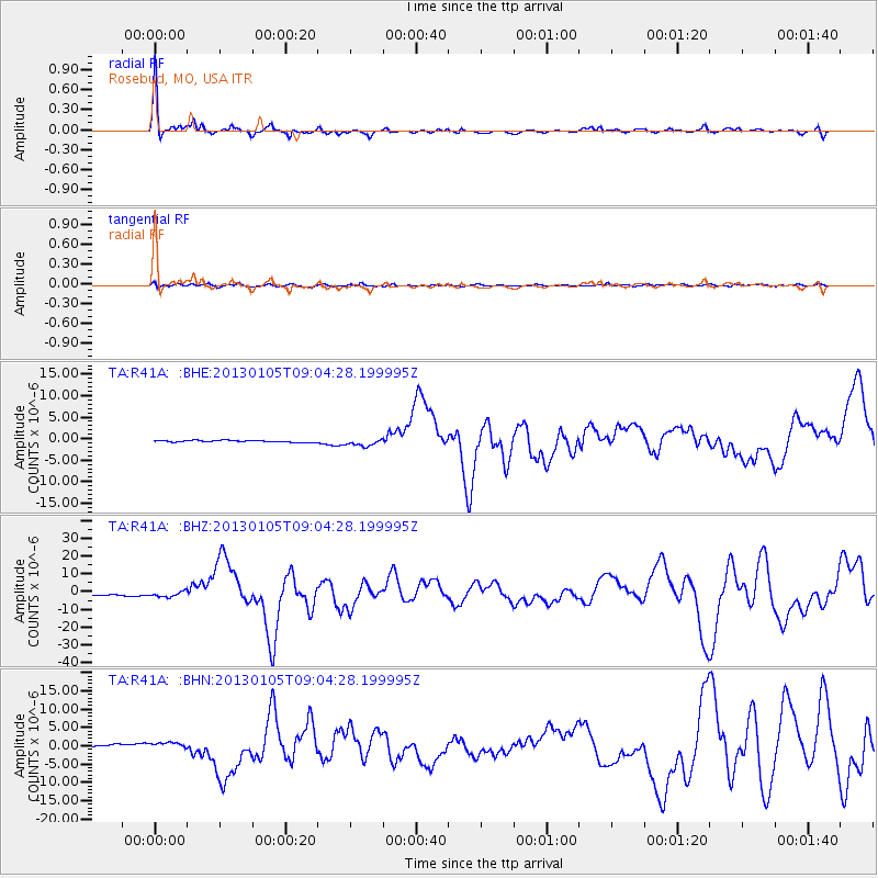
Signal To Noise
| Channel | StoN | STA | LTA |
| TA:R41A: :BHZ:20130105T09:04:28.199995Z | 3.7634158 | 1.5797594E-6 | 4.1976745E-7 |
| TA:R41A: :BHN:20130105T09:04:28.199995Z | 2.7729468 | 8.747695E-7 | 3.1546566E-7 |
| TA:R41A: :BHE:20130105T09:04:28.199995Z | 4.002114 | 8.4225235E-7 | 2.1045186E-7 |
| Arrivals |
| Ps | 6.1 SECOND |
| PpPs | 18 SECOND |
| PsPs/PpSs | 24 SECOND |


