You are here: Home > Network List > TA - USArray Transportable Network (new EarthScope stations) Stations List
> Station Q41A Truxton, MO, USA > Earthquake Result Viewer
Q41A Truxton, MO, USA - Earthquake Result Viewer
| Earthquake location: |
Southeastern Alaska |
| Earthquake latitude/longitude: |
55.4/-134.7 |
| Earthquake time(UTC): |
2013/01/05 (005) 08:58:19 GMT |
| Earthquake Depth: |
10 km |
| Earthquake Magnitude: |
6.4 MB, 7.7 MS, 7.5 MW, 7.5 MW |
| Earthquake Catalog/Contributor: |
WHDF/NEIC |
|
| Network: |
TA USArray Transportable Network (new EarthScope stations) |
| Station: |
Q41A Truxton, MO, USA |
| Lat/Lon: |
38.95 N/91.23 W |
| Elevation: |
191 m |
|
| Distance: |
33.1 deg |
| Az: |
101.381 deg |
| Baz: |
314.166 deg |
| Ray Param: |
0.078345135 |
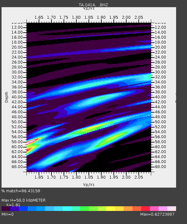
| Estimated Moho Depth: |
58.0 km |
| Estimated Crust Vp/Vs: |
1.61 |
| Assumed Crust Vp: |
6.498 km/s |
| Estimated Crust Vs: |
4.036 km/s |
| Estimated Crust Poisson's Ratio: |
0.19 |
|
| Radial Match: |
96.43159 % |
| Radial Bump: |
181 |
| Transverse Match: |
76.01173 % |
| Transverse Bump: |
400 |
| SOD ConfigId: |
492951 |
| Insert Time: |
2013-04-14 13:01:58.466 +0000 |
| GWidth: |
2.5 |
| Max Bumps: |
400 |
| Tol: |
0.001 |
|

Signal To Noise
| Channel | StoN | STA | LTA |
| TA:Q41A: :BHZ:20130105T09:04:24.925001Z | 2.6243677 | 1.3218859E-6 | 5.036969E-7 |
| TA:Q41A: :BHN:20130105T09:04:24.925001Z | 3.4164314 | 9.2882493E-7 | 2.718699E-7 |
| TA:Q41A: :BHE:20130105T09:04:24.925001Z | 3.329755 | 8.7082867E-7 | 2.6152935E-7 |
| Arrivals |
| Ps | 6.0 SECOND |
| PpPs | 21 SECOND |
| PsPs/PpSs | 27 SECOND |


