You are here: Home > Network List > TA - USArray Transportable Network (new EarthScope stations) Stations List
> Station T42A Van Buren, MO, USA > Earthquake Result Viewer
T42A Van Buren, MO, USA - Earthquake Result Viewer
| Earthquake location: |
Southeastern Alaska |
| Earthquake latitude/longitude: |
55.4/-134.7 |
| Earthquake time(UTC): |
2013/01/05 (005) 08:58:19 GMT |
| Earthquake Depth: |
10 km |
| Earthquake Magnitude: |
6.4 MB, 7.7 MS, 7.5 MW, 7.5 MW |
| Earthquake Catalog/Contributor: |
WHDF/NEIC |
|
| Network: |
TA USArray Transportable Network (new EarthScope stations) |
| Station: |
T42A Van Buren, MO, USA |
| Lat/Lon: |
37.03 N/91.09 W |
| Elevation: |
162 m |
|
| Distance: |
34.6 deg |
| Az: |
103.672 deg |
| Baz: |
316.154 deg |
| Ray Param: |
0.0776687 |
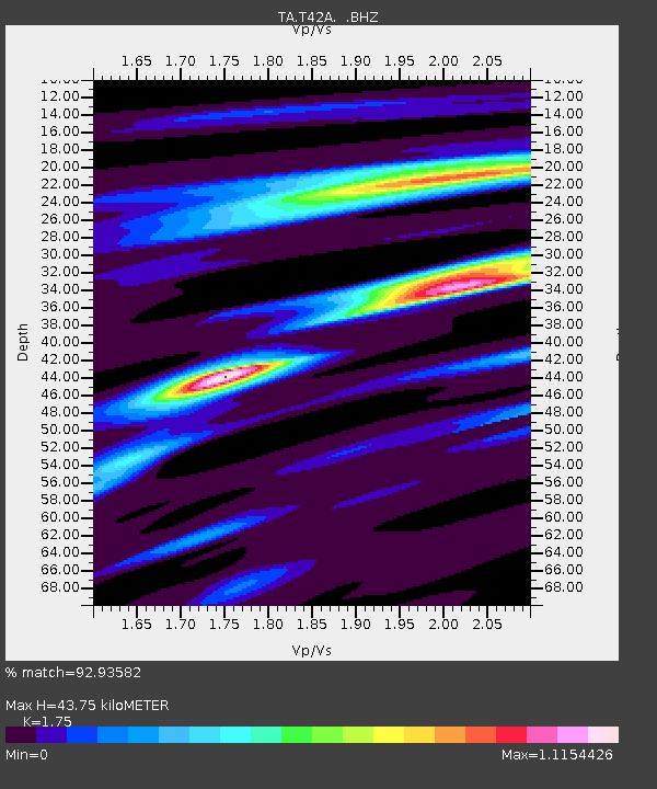
| Estimated Moho Depth: |
43.75 km |
| Estimated Crust Vp/Vs: |
1.75 |
| Assumed Crust Vp: |
6.53 km/s |
| Estimated Crust Vs: |
3.732 km/s |
| Estimated Crust Poisson's Ratio: |
0.26 |
|
| Radial Match: |
92.93582 % |
| Radial Bump: |
200 |
| Transverse Match: |
73.5854 % |
| Transverse Bump: |
400 |
| SOD ConfigId: |
492951 |
| Insert Time: |
2013-04-14 13:02:27.501 +0000 |
| GWidth: |
2.5 |
| Max Bumps: |
400 |
| Tol: |
0.001 |
|

Signal To Noise
| Channel | StoN | STA | LTA |
| TA:T42A: :BHZ:20130105T09:04:37.400007Z | 3.5270376 | 1.272307E-6 | 3.6072962E-7 |
| TA:T42A: :BHN:20130105T09:04:37.400007Z | 2.9022996 | 5.988263E-7 | 2.0632822E-7 |
| TA:T42A: :BHE:20130105T09:04:37.400007Z | 2.505625 | 5.7749907E-7 | 2.3048102E-7 |
| Arrivals |
| Ps | 5.4 SECOND |
| PpPs | 17 SECOND |
| PsPs/PpSs | 22 SECOND |


