You are here: Home > Network List > TA - USArray Transportable Network (new EarthScope stations) Stations List
> Station G41A Antigo, WI, USA > Earthquake Result Viewer
G41A Antigo, WI, USA - Earthquake Result Viewer
| Earthquake location: |
Southeastern Alaska |
| Earthquake latitude/longitude: |
55.4/-134.7 |
| Earthquake time(UTC): |
2013/01/05 (005) 08:58:19 GMT |
| Earthquake Depth: |
10 km |
| Earthquake Magnitude: |
6.4 MB, 7.7 MS, 7.5 MW, 7.5 MW |
| Earthquake Catalog/Contributor: |
WHDF/NEIC |
|
| Network: |
TA USArray Transportable Network (new EarthScope stations) |
| Station: |
G41A Antigo, WI, USA |
| Lat/Lon: |
45.21 N/89.18 W |
| Elevation: |
464 m |
|
| Distance: |
30.3 deg |
| Az: |
90.404 deg |
| Baz: |
306.186 deg |
| Ray Param: |
0.07937874 |
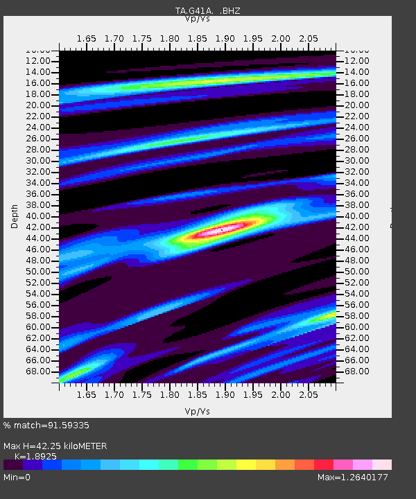
| Estimated Moho Depth: |
42.25 km |
| Estimated Crust Vp/Vs: |
1.89 |
| Assumed Crust Vp: |
6.41 km/s |
| Estimated Crust Vs: |
3.387 km/s |
| Estimated Crust Poisson's Ratio: |
0.31 |
|
| Radial Match: |
91.59335 % |
| Radial Bump: |
314 |
| Transverse Match: |
81.927925 % |
| Transverse Bump: |
400 |
| SOD ConfigId: |
492951 |
| Insert Time: |
2013-04-14 13:03:08.903 +0000 |
| GWidth: |
2.5 |
| Max Bumps: |
400 |
| Tol: |
0.001 |
|

Signal To Noise
| Channel | StoN | STA | LTA |
| TA:G41A: :BHZ:20130105T09:03:59.675001Z | 2.3468757 | 1.1213853E-6 | 4.778205E-7 |
| TA:G41A: :BHN:20130105T09:03:59.675001Z | 2.761619 | 7.7342565E-7 | 2.800624E-7 |
| TA:G41A: :BHE:20130105T09:03:59.675001Z | 3.1569958 | 1.0417149E-6 | 3.2997033E-7 |
| Arrivals |
| Ps | 6.3 SECOND |
| PpPs | 18 SECOND |
| PsPs/PpSs | 24 SECOND |


