You are here: Home > Network List > TA - USArray Transportable Network (new EarthScope stations) Stations List
> Station J43A Natural Harvest Farm, Hartford, WI, USA > Earthquake Result Viewer
J43A Natural Harvest Farm, Hartford, WI, USA - Earthquake Result Viewer
| Earthquake location: |
Southeastern Alaska |
| Earthquake latitude/longitude: |
55.4/-134.7 |
| Earthquake time(UTC): |
2013/01/05 (005) 08:58:19 GMT |
| Earthquake Depth: |
10 km |
| Earthquake Magnitude: |
6.4 MB, 7.7 MS, 7.5 MW, 7.5 MW |
| Earthquake Catalog/Contributor: |
WHDF/NEIC |
|
| Network: |
TA USArray Transportable Network (new EarthScope stations) |
| Station: |
J43A Natural Harvest Farm, Hartford, WI, USA |
| Lat/Lon: |
43.38 N/88.42 W |
| Elevation: |
322 m |
|
| Distance: |
31.8 deg |
| Az: |
92.58 deg |
| Baz: |
308.582 deg |
| Ray Param: |
0.07891986 |
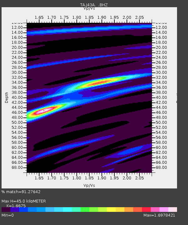
| Estimated Moho Depth: |
45.0 km |
| Estimated Crust Vp/Vs: |
1.67 |
| Assumed Crust Vp: |
6.571 km/s |
| Estimated Crust Vs: |
3.94 km/s |
| Estimated Crust Poisson's Ratio: |
0.22 |
|
| Radial Match: |
91.27642 % |
| Radial Bump: |
210 |
| Transverse Match: |
72.53542 % |
| Transverse Bump: |
389 |
| SOD ConfigId: |
492951 |
| Insert Time: |
2013-04-14 13:05:03.083 +0000 |
| GWidth: |
2.5 |
| Max Bumps: |
400 |
| Tol: |
0.001 |
|
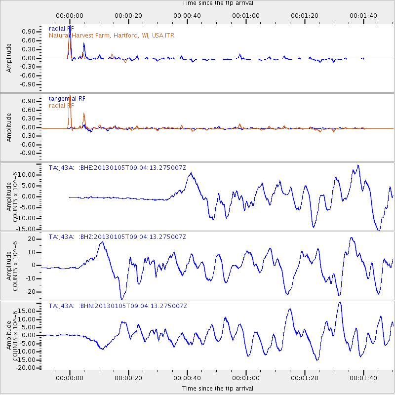
Signal To Noise
| Channel | StoN | STA | LTA |
| TA:J43A: :BHZ:20130105T09:04:13.275007Z | 2.220499 | 9.831335E-7 | 4.4275342E-7 |
| TA:J43A: :BHN:20130105T09:04:13.275007Z | 1.7325748 | 5.103813E-7 | 2.9457968E-7 |
| TA:J43A: :BHE:20130105T09:04:13.275007Z | 3.1070025 | 7.8082746E-7 | 2.5131214E-7 |
| Arrivals |
| Ps | 5.0 SECOND |
| PpPs | 17 SECOND |
| PsPs/PpSs | 22 SECOND |


