You are here: Home > Network List > TA - USArray Transportable Network (new EarthScope stations) Stations List
> Station K43A Burlington, WI, USA > Earthquake Result Viewer
K43A Burlington, WI, USA - Earthquake Result Viewer
| Earthquake location: |
Southeastern Alaska |
| Earthquake latitude/longitude: |
55.4/-134.7 |
| Earthquake time(UTC): |
2013/01/05 (005) 08:58:19 GMT |
| Earthquake Depth: |
10 km |
| Earthquake Magnitude: |
6.4 MB, 7.7 MS, 7.5 MW, 7.5 MW |
| Earthquake Catalog/Contributor: |
WHDF/NEIC |
|
| Network: |
TA USArray Transportable Network (new EarthScope stations) |
| Station: |
K43A Burlington, WI, USA |
| Lat/Lon: |
42.70 N/88.33 W |
| Elevation: |
264 m |
|
| Distance: |
32.3 deg |
| Az: |
93.495 deg |
| Baz: |
309.417 deg |
| Ray Param: |
0.07871796 |
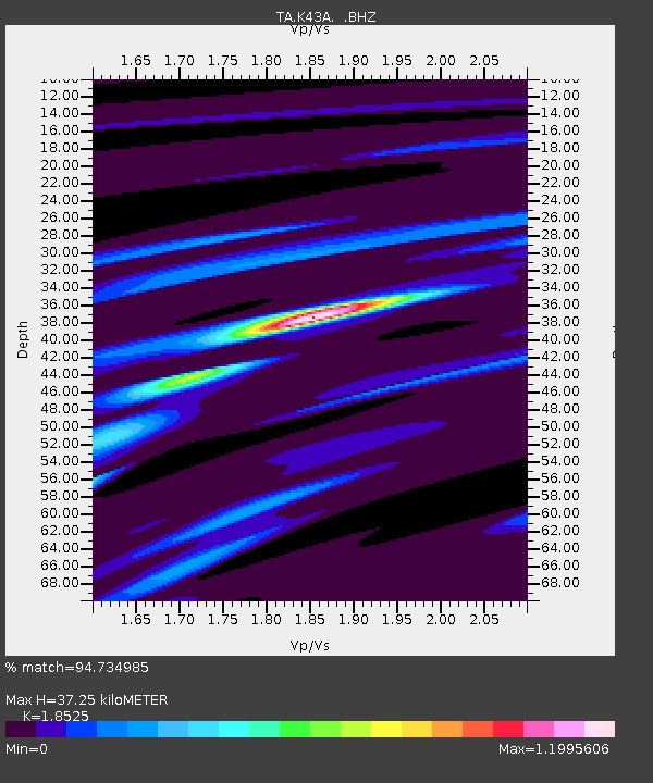
| Estimated Moho Depth: |
37.25 km |
| Estimated Crust Vp/Vs: |
1.85 |
| Assumed Crust Vp: |
6.571 km/s |
| Estimated Crust Vs: |
3.547 km/s |
| Estimated Crust Poisson's Ratio: |
0.29 |
|
| Radial Match: |
94.734985 % |
| Radial Bump: |
211 |
| Transverse Match: |
68.73898 % |
| Transverse Bump: |
400 |
| SOD ConfigId: |
492951 |
| Insert Time: |
2013-04-14 13:05:59.482 +0000 |
| GWidth: |
2.5 |
| Max Bumps: |
400 |
| Tol: |
0.001 |
|

Signal To Noise
| Channel | StoN | STA | LTA |
| TA:K43A: :BHZ:20130105T09:04:17.425001Z | 2.9539564 | 1.2319822E-6 | 4.1706173E-7 |
| TA:K43A: :BHN:20130105T09:04:17.425001Z | 0.7946495 | 3.702776E-7 | 4.6596344E-7 |
| TA:K43A: :BHE:20130105T09:04:17.425001Z | 2.4079924 | 8.358745E-7 | 3.4712505E-7 |
| Arrivals |
| Ps | 5.2 SECOND |
| PpPs | 15 SECOND |
| PsPs/PpSs | 20 SECOND |


