You are here: Home > Network List > TA - USArray Transportable Network (new EarthScope stations) Stations List
> Station N43A Stutzman Family Farm, Minonk, IL, USA > Earthquake Result Viewer
N43A Stutzman Family Farm, Minonk, IL, USA - Earthquake Result Viewer
| Earthquake location: |
Southeastern Alaska |
| Earthquake latitude/longitude: |
55.4/-134.7 |
| Earthquake time(UTC): |
2013/01/05 (005) 08:58:19 GMT |
| Earthquake Depth: |
10 km |
| Earthquake Magnitude: |
6.4 MB, 7.7 MS, 7.5 MW, 7.5 MW |
| Earthquake Catalog/Contributor: |
WHDF/NEIC |
|
| Network: |
TA USArray Transportable Network (new EarthScope stations) |
| Station: |
N43A Stutzman Family Farm, Minonk, IL, USA |
| Lat/Lon: |
40.94 N/89.17 W |
| Elevation: |
215 m |
|
| Distance: |
32.9 deg |
| Az: |
96.741 deg |
| Baz: |
311.592 deg |
| Ray Param: |
0.078432776 |
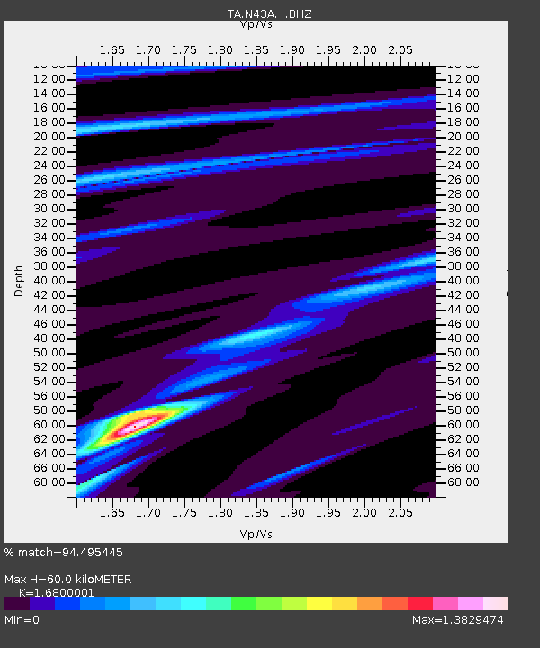
| Estimated Moho Depth: |
60.0 km |
| Estimated Crust Vp/Vs: |
1.68 |
| Assumed Crust Vp: |
6.498 km/s |
| Estimated Crust Vs: |
3.868 km/s |
| Estimated Crust Poisson's Ratio: |
0.23 |
|
| Radial Match: |
94.495445 % |
| Radial Bump: |
200 |
| Transverse Match: |
63.75487 % |
| Transverse Bump: |
400 |
| SOD ConfigId: |
492951 |
| Insert Time: |
2013-04-14 13:07:01.968 +0000 |
| GWidth: |
2.5 |
| Max Bumps: |
400 |
| Tol: |
0.001 |
|
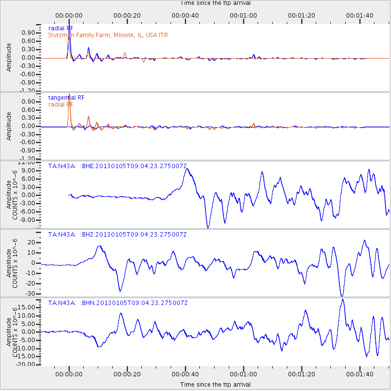
Signal To Noise
| Channel | StoN | STA | LTA |
| TA:N43A: :BHZ:20130105T09:04:23.275007Z | 2.4970489 | 1.082822E-6 | 4.3364068E-7 |
| TA:N43A: :BHN:20130105T09:04:23.275007Z | 1.884021 | 4.617429E-7 | 2.4508373E-7 |
| TA:N43A: :BHE:20130105T09:04:23.275007Z | 2.1998332 | 6.6777994E-7 | 3.0355937E-7 |
| Arrivals |
| Ps | 6.8 SECOND |
| PpPs | 23 SECOND |
| PsPs/PpSs | 30 SECOND |


