You are here: Home > Network List > TA - USArray Transportable Network (new EarthScope stations) Stations List
> Station T48A Bowling Green, KY, USA > Earthquake Result Viewer
T48A Bowling Green, KY, USA - Earthquake Result Viewer
| Earthquake location: |
Southeastern Alaska |
| Earthquake latitude/longitude: |
55.4/-134.7 |
| Earthquake time(UTC): |
2013/01/05 (005) 08:58:19 GMT |
| Earthquake Depth: |
10 km |
| Earthquake Magnitude: |
6.4 MB, 7.7 MS, 7.5 MW, 7.5 MW |
| Earthquake Catalog/Contributor: |
WHDF/NEIC |
|
| Network: |
TA USArray Transportable Network (new EarthScope stations) |
| Station: |
T48A Bowling Green, KY, USA |
| Lat/Lon: |
37.11 N/86.39 W |
| Elevation: |
218 m |
|
| Distance: |
37.2 deg |
| Az: |
98.99 deg |
| Baz: |
315.178 deg |
| Ray Param: |
0.07629252 |
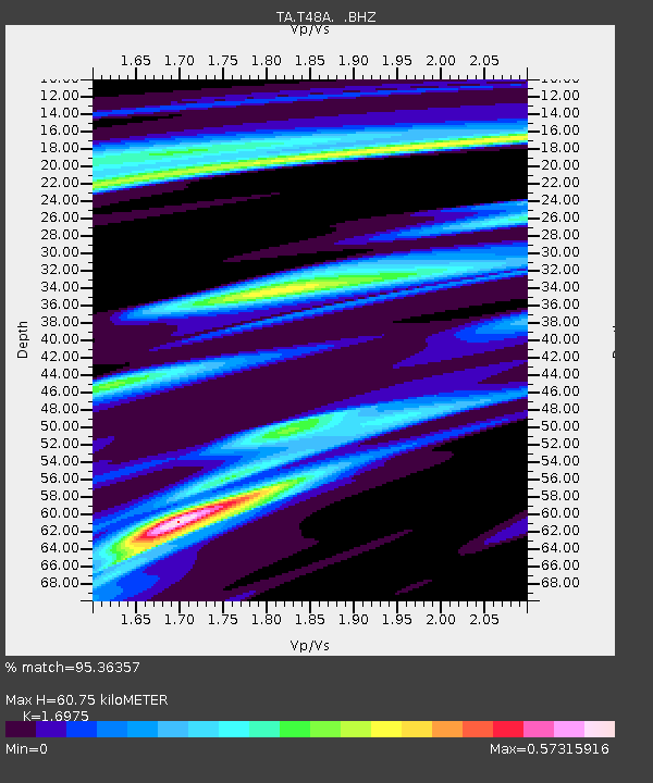
| Estimated Moho Depth: |
60.75 km |
| Estimated Crust Vp/Vs: |
1.70 |
| Assumed Crust Vp: |
6.444 km/s |
| Estimated Crust Vs: |
3.796 km/s |
| Estimated Crust Poisson's Ratio: |
0.23 |
|
| Radial Match: |
95.36357 % |
| Radial Bump: |
222 |
| Transverse Match: |
68.812004 % |
| Transverse Bump: |
394 |
| SOD ConfigId: |
492951 |
| Insert Time: |
2013-04-14 13:08:25.723 +0000 |
| GWidth: |
2.5 |
| Max Bumps: |
400 |
| Tol: |
0.001 |
|
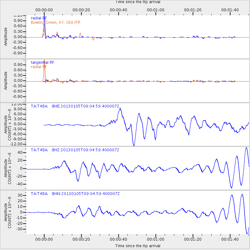
Signal To Noise
| Channel | StoN | STA | LTA |
| TA:T48A: :BHZ:20130105T09:04:59.400007Z | 3.6504123 | 1.0659284E-6 | 2.9200217E-7 |
| TA:T48A: :BHN:20130105T09:04:59.400007Z | 1.8027843 | 4.5687233E-7 | 2.5342595E-7 |
| TA:T48A: :BHE:20130105T09:04:59.400007Z | 2.1199217 | 4.5890496E-7 | 2.164726E-7 |
| Arrivals |
| Ps | 7.1 SECOND |
| PpPs | 24 SECOND |
| PsPs/PpSs | 31 SECOND |


