You are here: Home > Network List > TA - USArray Transportable Network (new EarthScope stations) Stations List
> Station S46A Don Dixon Farm, Corydon, KY, USA > Earthquake Result Viewer
S46A Don Dixon Farm, Corydon, KY, USA - Earthquake Result Viewer

| Earthquake location: |
Southeastern Alaska |
| Earthquake latitude/longitude: |
55.4/-134.7 |
| Earthquake time(UTC): |
2013/01/05 (005) 08:58:19 GMT |
| Earthquake Depth: |
10 km |
| Earthquake Magnitude: |
6.4 MB, 7.7 MS, 7.5 MW, 7.5 MW |
| Earthquake Catalog/Contributor: |
WHDF/NEIC |
|
| Network: |
TA USArray Transportable Network (new EarthScope stations) |
| Station: |
S46A Don Dixon Farm, Corydon, KY, USA |
| Lat/Lon: |
37.68 N/87.72 W |
| Elevation: |
125 m |
|
| Distance: |
36.0 deg |
| Az: |
99.557 deg |
| Baz: |
314.835 deg |
| Ray Param: |
0.07691903 |
| Estimated Moho Depth: |
39.5 km |
| Estimated Crust Vp/Vs: |
1.94 |
| Assumed Crust Vp: |
6.444 km/s |
| Estimated Crust Vs: |
3.322 km/s |
| Estimated Crust Poisson's Ratio: |
0.32 |
|
| Radial Match: |
92.31298 % |
| Radial Bump: |
149 |
| Transverse Match: |
64.33557 % |
| Transverse Bump: |
342 |
| SOD ConfigId: |
492951 |
| Insert Time: |
2013-04-14 13:09:05.135 +0000 |
| GWidth: |
2.5 |
| Max Bumps: |
400 |
| Tol: |
0.001 |
|
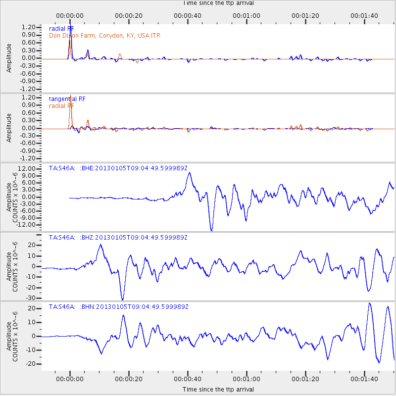
Signal To Noise
| Channel | StoN | STA | LTA |
| TA:S46A: :BHZ:20130105T09:04:49.599989Z | 3.0139089 | 1.2027689E-6 | 3.9907275E-7 |
| TA:S46A: :BHN:20130105T09:04:49.599989Z | 2.8862336 | 7.444069E-7 | 2.5791638E-7 |
| TA:S46A: :BHE:20130105T09:04:49.599989Z | 3.1851063 | 7.0450074E-7 | 2.2118594E-7 |
| Arrivals |
| Ps | 6.2 SECOND |
| PpPs | 17 SECOND |
| PsPs/PpSs | 23 SECOND |


