You are here: Home > Network List > TA - USArray Transportable Network (new EarthScope stations) Stations List
> Station 150A Eclectic, AL, USA > Earthquake Result Viewer
150A Eclectic, AL, USA - Earthquake Result Viewer
| Earthquake location: |
Southeastern Alaska |
| Earthquake latitude/longitude: |
55.4/-134.7 |
| Earthquake time(UTC): |
2013/01/05 (005) 08:58:19 GMT |
| Earthquake Depth: |
10 km |
| Earthquake Magnitude: |
6.4 MB, 7.7 MS, 7.5 MW, 7.5 MW |
| Earthquake Catalog/Contributor: |
WHDF/NEIC |
|
| Network: |
TA USArray Transportable Network (new EarthScope stations) |
| Station: |
150A Eclectic, AL, USA |
| Lat/Lon: |
32.61 N/86.02 W |
| Elevation: |
145 m |
|
| Distance: |
40.6 deg |
| Az: |
103.508 deg |
| Baz: |
318.909 deg |
| Ray Param: |
0.07427784 |
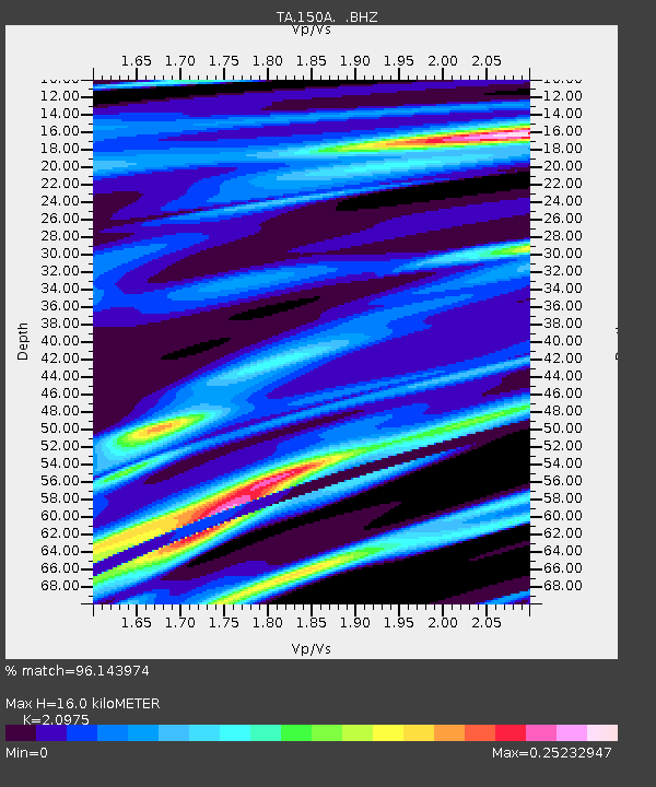
| Estimated Moho Depth: |
16.0 km |
| Estimated Crust Vp/Vs: |
2.10 |
| Assumed Crust Vp: |
6.565 km/s |
| Estimated Crust Vs: |
3.13 km/s |
| Estimated Crust Poisson's Ratio: |
0.35 |
|
| Radial Match: |
96.143974 % |
| Radial Bump: |
238 |
| Transverse Match: |
66.92983 % |
| Transverse Bump: |
400 |
| SOD ConfigId: |
492951 |
| Insert Time: |
2013-04-14 13:11:33.529 +0000 |
| GWidth: |
2.5 |
| Max Bumps: |
400 |
| Tol: |
0.001 |
|
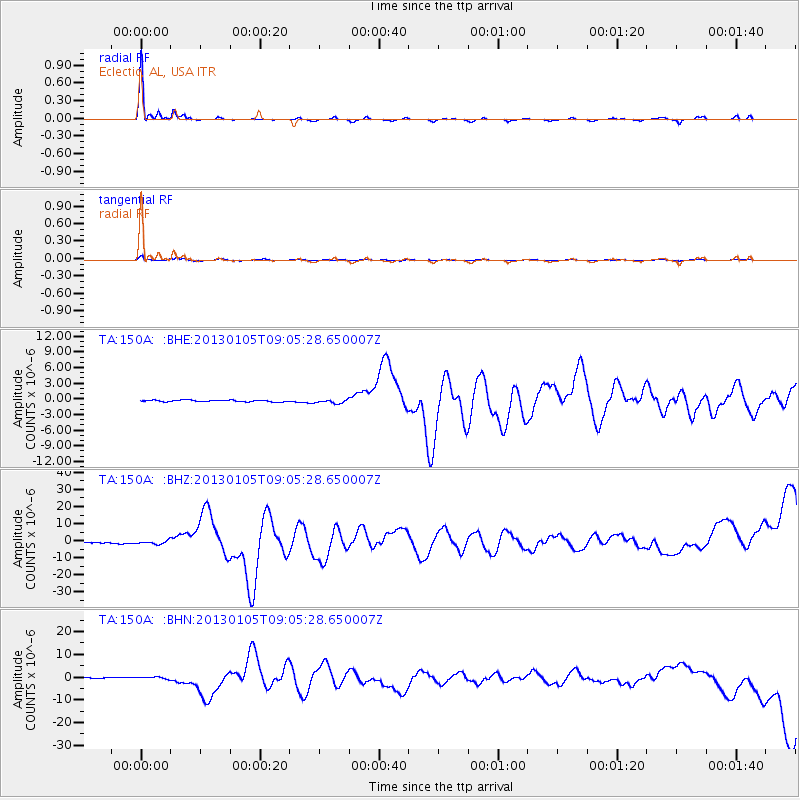
Signal To Noise
| Channel | StoN | STA | LTA |
| TA:150A: :BHZ:20130105T09:05:28.650007Z | 4.7894115 | 9.1267464E-7 | 1.9056091E-7 |
| TA:150A: :BHN:20130105T09:05:28.650007Z | 2.6440866 | 4.3272098E-7 | 1.6365613E-7 |
| TA:150A: :BHE:20130105T09:05:28.650007Z | 2.0965853 | 3.499702E-7 | 1.6692391E-7 |
| Arrivals |
| Ps | 2.8 SECOND |
| PpPs | 7.1 SECOND |
| PsPs/PpSs | 9.9 SECOND |


