You are here: Home > Network List > TA - USArray Transportable Network (new EarthScope stations) Stations List
> Station 353A Camilla, GA, USA > Earthquake Result Viewer
353A Camilla, GA, USA - Earthquake Result Viewer
| Earthquake location: |
Southeastern Alaska |
| Earthquake latitude/longitude: |
55.4/-134.7 |
| Earthquake time(UTC): |
2013/01/05 (005) 08:58:19 GMT |
| Earthquake Depth: |
10 km |
| Earthquake Magnitude: |
6.4 MB, 7.7 MS, 7.5 MW, 7.5 MW |
| Earthquake Catalog/Contributor: |
WHDF/NEIC |
|
| Network: |
TA USArray Transportable Network (new EarthScope stations) |
| Station: |
353A Camilla, GA, USA |
| Lat/Lon: |
31.35 N/84.22 W |
| Elevation: |
54 m |
|
| Distance: |
42.6 deg |
| Az: |
102.995 deg |
| Baz: |
319.477 deg |
| Ray Param: |
0.07308054 |
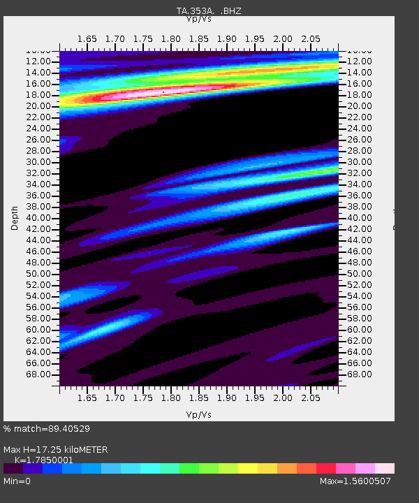
| Estimated Moho Depth: |
17.25 km |
| Estimated Crust Vp/Vs: |
1.79 |
| Assumed Crust Vp: |
6.347 km/s |
| Estimated Crust Vs: |
3.556 km/s |
| Estimated Crust Poisson's Ratio: |
0.27 |
|
| Radial Match: |
89.40529 % |
| Radial Bump: |
391 |
| Transverse Match: |
43.93255 % |
| Transverse Bump: |
380 |
| SOD ConfigId: |
492951 |
| Insert Time: |
2013-04-14 13:14:15.683 +0000 |
| GWidth: |
2.5 |
| Max Bumps: |
400 |
| Tol: |
0.001 |
|
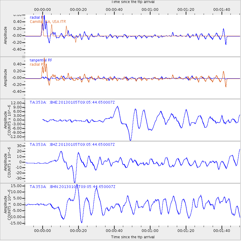
Signal To Noise
| Channel | StoN | STA | LTA |
| TA:353A: :BHZ:20130105T09:05:44.650007Z | 2.6222823 | 1.0492369E-6 | 4.0012353E-7 |
| TA:353A: :BHN:20130105T09:05:44.650007Z | 1.3398778 | 7.1201487E-7 | 5.314028E-7 |
| TA:353A: :BHE:20130105T09:05:44.650007Z | 1.3109741 | 5.73442E-7 | 4.374167E-7 |
| Arrivals |
| Ps | 2.3 SECOND |
| PpPs | 7.1 SECOND |
| PsPs/PpSs | 9.4 SECOND |


