You are here: Home > Network List > TA - USArray Transportable Network (new EarthScope stations) Stations List
> Station 253A Americus, GA, USA > Earthquake Result Viewer
253A Americus, GA, USA - Earthquake Result Viewer

| Earthquake location: |
Southeastern Alaska |
| Earthquake latitude/longitude: |
55.4/-134.7 |
| Earthquake time(UTC): |
2013/01/05 (005) 08:58:19 GMT |
| Earthquake Depth: |
10 km |
| Earthquake Magnitude: |
6.4 MB, 7.7 MS, 7.5 MW, 7.5 MW |
| Earthquake Catalog/Contributor: |
WHDF/NEIC |
|
| Network: |
TA USArray Transportable Network (new EarthScope stations) |
| Station: |
253A Americus, GA, USA |
| Lat/Lon: |
32.06 N/84.13 W |
| Elevation: |
136 m |
|
| Distance: |
42.1 deg |
| Az: |
102.221 deg |
| Baz: |
318.951 deg |
| Ray Param: |
0.07336266 |
| Estimated Moho Depth: |
13.75 km |
| Estimated Crust Vp/Vs: |
1.77 |
| Assumed Crust Vp: |
6.719 km/s |
| Estimated Crust Vs: |
3.786 km/s |
| Estimated Crust Poisson's Ratio: |
0.27 |
|
| Radial Match: |
90.21736 % |
| Radial Bump: |
400 |
| Transverse Match: |
71.97728 % |
| Transverse Bump: |
400 |
| SOD ConfigId: |
492951 |
| Insert Time: |
2013-04-14 13:14:27.684 +0000 |
| GWidth: |
2.5 |
| Max Bumps: |
400 |
| Tol: |
0.001 |
|
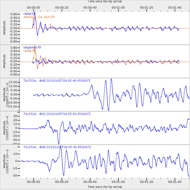
Signal To Noise
| Channel | StoN | STA | LTA |
| TA:253A: :BHZ:20130105T09:05:40.650007Z | 4.161686 | 1.3861112E-6 | 3.3306483E-7 |
| TA:253A: :BHN:20130105T09:05:40.650007Z | 1.4243731 | 6.724003E-7 | 4.720675E-7 |
| TA:253A: :BHE:20130105T09:05:40.650007Z | 0.9448965 | 6.845966E-7 | 7.245202E-7 |
| Arrivals |
| Ps | 1.7 SECOND |
| PpPs | 5.3 SECOND |
| PsPs/PpSs | 7.0 SECOND |


