You are here: Home > Network List > TA - USArray Transportable Network (new EarthScope stations) Stations List
> Station 355A Pearson, GA, USA > Earthquake Result Viewer
355A Pearson, GA, USA - Earthquake Result Viewer
| Earthquake location: |
Southeastern Alaska |
| Earthquake latitude/longitude: |
55.4/-134.7 |
| Earthquake time(UTC): |
2013/01/05 (005) 08:58:19 GMT |
| Earthquake Depth: |
10 km |
| Earthquake Magnitude: |
6.4 MB, 7.7 MS, 7.5 MW, 7.5 MW |
| Earthquake Catalog/Contributor: |
WHDF/NEIC |
|
| Network: |
TA USArray Transportable Network (new EarthScope stations) |
| Station: |
355A Pearson, GA, USA |
| Lat/Lon: |
31.34 N/82.85 W |
| Elevation: |
69 m |
|
| Distance: |
43.4 deg |
| Az: |
101.699 deg |
| Baz: |
319.235 deg |
| Ray Param: |
0.0725991 |
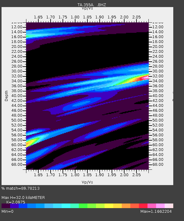
| Estimated Moho Depth: |
32.0 km |
| Estimated Crust Vp/Vs: |
2.10 |
| Assumed Crust Vp: |
6.565 km/s |
| Estimated Crust Vs: |
3.13 km/s |
| Estimated Crust Poisson's Ratio: |
0.35 |
|
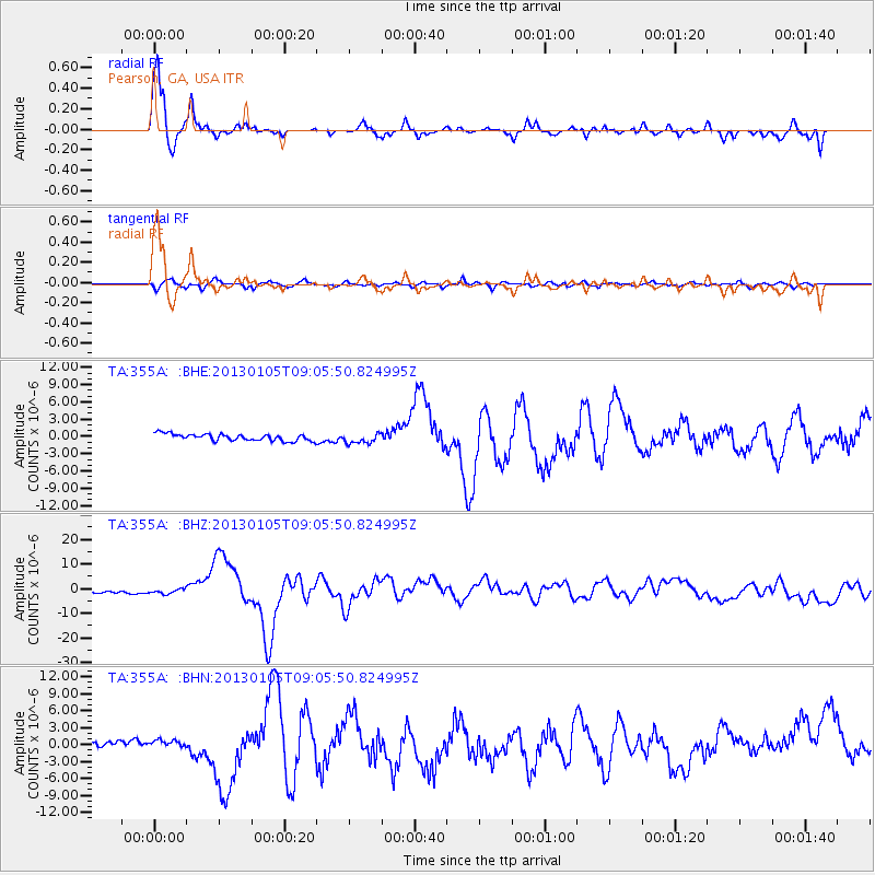
| Radial Match: |
89.78213 % |
| Radial Bump: |
306 |
| Transverse Match: |
56.644596 % |
| Transverse Bump: |
336 |
| SOD ConfigId: |
492951 |
| Insert Time: |
2013-04-14 13:14:48.758 +0000 |
| GWidth: |
2.5 |
| Max Bumps: |
400 |
| Tol: |
0.001 |
|
Signal To Noise
| Channel | StoN | STA | LTA |
| TA:355A: :BHZ:20130105T09:05:50.824995Z | 1.8280032 | 1.0392693E-6 | 5.68527E-7 |
| TA:355A: :BHN:20130105T09:05:50.824995Z | 1.3638495 | 8.1012627E-7 | 5.9399974E-7 |
| TA:355A: :BHE:20130105T09:05:50.824995Z | 1.5019838 | 8.936884E-7 | 5.9500536E-7 |
| Arrivals |
| Ps | 5.7 SECOND |
| PpPs | 14 SECOND |
| PsPs/PpSs | 20 SECOND |


