You are here: Home > Network List > TA - USArray Transportable Network (new EarthScope stations) Stations List
> Station 255A Hazlehurst, GA, USA > Earthquake Result Viewer
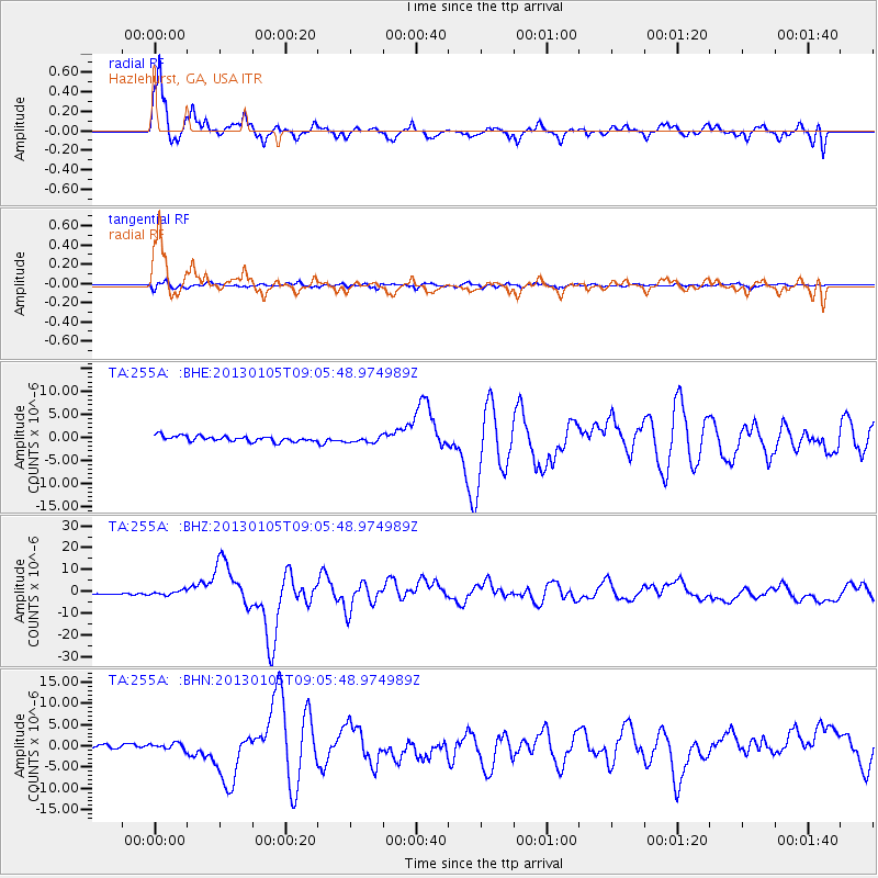
255A Hazlehurst, GA, USA - Earthquake Result Viewer

| Earthquake location: |
Southeastern Alaska |
| Earthquake latitude/longitude: |
55.4/-134.7 |
| Earthquake time(UTC): |
2013/01/05 (005) 08:58:19 GMT |
| Earthquake Depth: |
10 km |
| Earthquake Magnitude: |
6.4 MB, 7.7 MS, 7.5 MW, 7.5 MW |
| Earthquake Catalog/Contributor: |
WHDF/NEIC |
|
| Network: |
TA USArray Transportable Network (new EarthScope stations) |
| Station: |
255A Hazlehurst, GA, USA |
| Lat/Lon: |
31.93 N/82.48 W |
| Elevation: |
45 m |
|
| Distance: |
43.1 deg |
| Az: |
100.789 deg |
| Baz: |
318.769 deg |
| Ray Param: |
0.07274554 |
| Estimated Moho Depth: |
27.0 km |
| Estimated Crust Vp/Vs: |
2.10 |
| Assumed Crust Vp: |
6.565 km/s |
| Estimated Crust Vs: |
3.13 km/s |
| Estimated Crust Poisson's Ratio: |
0.35 |
|
| Radial Match: |
85.820694 % |
| Radial Bump: |
372 |
| Transverse Match: |
46.496506 % |
| Transverse Bump: |
399 |
| SOD ConfigId: |
492951 |
| Insert Time: |
2013-04-14 13:16:12.627 +0000 |
| GWidth: |
2.5 |
| Max Bumps: |
400 |
| Tol: |
0.001 |
|
Signal To Noise
| Channel | StoN | STA | LTA |
| TA:255A: :BHZ:20130105T09:05:48.974989Z | 2.122116 | 9.985057E-7 | 4.7052362E-7 |
| TA:255A: :BHN:20130105T09:05:48.974989Z | 1.5201198 | 9.089864E-7 | 5.9797026E-7 |
| TA:255A: :BHE:20130105T09:05:48.974989Z | 1.2079718 | 7.135721E-7 | 5.9071914E-7 |
| Arrivals |
| Ps | 4.8 SECOND |
| PpPs | 12 SECOND |
| PsPs/PpSs | 17 SECOND |


