You are here: Home > Network List > TA - USArray Transportable Network (new EarthScope stations) Stations List
> Station 156A Sylvania, GA, USA > Earthquake Result Viewer
156A Sylvania, GA, USA - Earthquake Result Viewer
| Earthquake location: |
Southeastern Alaska |
| Earthquake latitude/longitude: |
55.4/-134.7 |
| Earthquake time(UTC): |
2013/01/05 (005) 08:58:19 GMT |
| Earthquake Depth: |
10 km |
| Earthquake Magnitude: |
6.4 MB, 7.7 MS, 7.5 MW, 7.5 MW |
| Earthquake Catalog/Contributor: |
WHDF/NEIC |
|
| Network: |
TA USArray Transportable Network (new EarthScope stations) |
| Station: |
156A Sylvania, GA, USA |
| Lat/Lon: |
32.65 N/81.50 W |
| Elevation: |
40 m |
|
| Distance: |
43.1 deg |
| Az: |
99.176 deg |
| Baz: |
318.113 deg |
| Ray Param: |
0.0727404 |
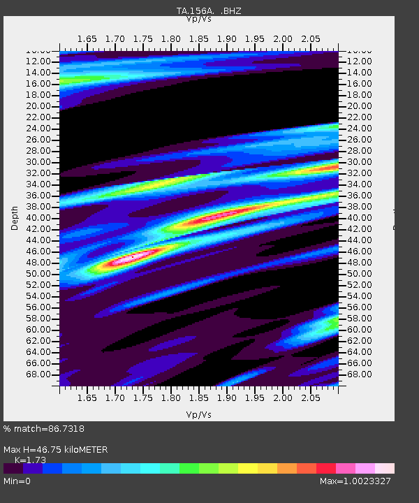
| Estimated Moho Depth: |
46.75 km |
| Estimated Crust Vp/Vs: |
1.73 |
| Assumed Crust Vp: |
6.565 km/s |
| Estimated Crust Vs: |
3.795 km/s |
| Estimated Crust Poisson's Ratio: |
0.25 |
|
| Radial Match: |
86.7318 % |
| Radial Bump: |
283 |
| Transverse Match: |
53.94661 % |
| Transverse Bump: |
400 |
| SOD ConfigId: |
492951 |
| Insert Time: |
2013-04-14 13:16:27.985 +0000 |
| GWidth: |
2.5 |
| Max Bumps: |
400 |
| Tol: |
0.001 |
|

Signal To Noise
| Channel | StoN | STA | LTA |
| TA:156A: :BHZ:20130105T09:05:49.050001Z | 1.9465902 | 1.0013076E-6 | 5.1439054E-7 |
| TA:156A: :BHN:20130105T09:05:49.050001Z | 1.1540982 | 7.746384E-7 | 6.712067E-7 |
| TA:156A: :BHE:20130105T09:05:49.050001Z | 1.15675 | 7.278163E-7 | 6.291907E-7 |
| Arrivals |
| Ps | 5.6 SECOND |
| PpPs | 18 SECOND |
| PsPs/PpSs | 24 SECOND |


