You are here: Home > Network List > TA - USArray Transportable Network (new EarthScope stations) Stations List
> Station Z54A Sparta, GA, USA > Earthquake Result Viewer
Z54A Sparta, GA, USA - Earthquake Result Viewer
| Earthquake location: |
Southeastern Alaska |
| Earthquake latitude/longitude: |
55.4/-134.7 |
| Earthquake time(UTC): |
2013/01/05 (005) 08:58:19 GMT |
| Earthquake Depth: |
10 km |
| Earthquake Magnitude: |
6.4 MB, 7.7 MS, 7.5 MW, 7.5 MW |
| Earthquake Catalog/Contributor: |
WHDF/NEIC |
|
| Network: |
TA USArray Transportable Network (new EarthScope stations) |
| Station: |
Z54A Sparta, GA, USA |
| Lat/Lon: |
33.24 N/82.84 W |
| Elevation: |
134 m |
|
| Distance: |
42.0 deg |
| Az: |
99.846 deg |
| Baz: |
317.878 deg |
| Ray Param: |
0.073462196 |
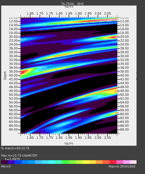
| Estimated Moho Depth: |
10.75 km |
| Estimated Crust Vp/Vs: |
2.10 |
| Assumed Crust Vp: |
6.565 km/s |
| Estimated Crust Vs: |
3.13 km/s |
| Estimated Crust Poisson's Ratio: |
0.35 |
|
| Radial Match: |
95.0179 % |
| Radial Bump: |
208 |
| Transverse Match: |
60.993656 % |
| Transverse Bump: |
400 |
| SOD ConfigId: |
492951 |
| Insert Time: |
2013-04-14 13:17:55.286 +0000 |
| GWidth: |
2.5 |
| Max Bumps: |
400 |
| Tol: |
0.001 |
|
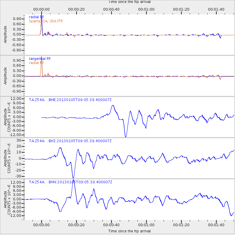
Signal To Noise
| Channel | StoN | STA | LTA |
| TA:Z54A: :BHZ:20130105T09:05:39.400007Z | 4.30441 | 9.106972E-7 | 2.1157307E-7 |
| TA:Z54A: :BHN:20130105T09:05:39.400007Z | 2.9939766 | 3.9354669E-7 | 1.3144614E-7 |
| TA:Z54A: :BHE:20130105T09:05:39.400007Z | 1.8195636 | 4.0699382E-7 | 2.2367661E-7 |
| Arrivals |
| Ps | 1.9 SECOND |
| PpPs | 4.8 SECOND |
| PsPs/PpSs | 6.7 SECOND |


