You are here: Home > Network List > TA - USArray Transportable Network (new EarthScope stations) Stations List
> Station Y53A Monroe, GA, USA > Earthquake Result Viewer
Y53A Monroe, GA, USA - Earthquake Result Viewer
| Earthquake location: |
Southeastern Alaska |
| Earthquake latitude/longitude: |
55.4/-134.7 |
| Earthquake time(UTC): |
2013/01/05 (005) 08:58:19 GMT |
| Earthquake Depth: |
10 km |
| Earthquake Magnitude: |
6.4 MB, 7.7 MS, 7.5 MW, 7.5 MW |
| Earthquake Catalog/Contributor: |
WHDF/NEIC |
|
| Network: |
TA USArray Transportable Network (new EarthScope stations) |
| Station: |
Y53A Monroe, GA, USA |
| Lat/Lon: |
33.86 N/83.58 W |
| Elevation: |
234 m |
|
| Distance: |
41.1 deg |
| Az: |
99.91 deg |
| Baz: |
317.518 deg |
| Ray Param: |
0.07401424 |
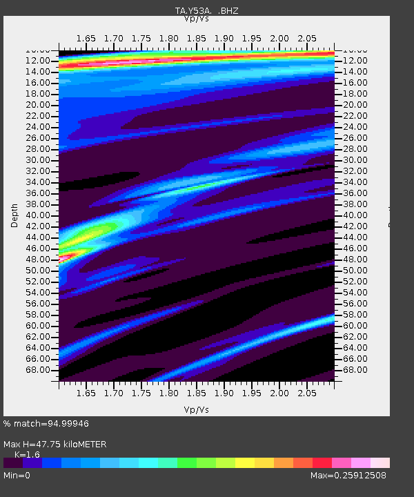
| Estimated Moho Depth: |
47.75 km |
| Estimated Crust Vp/Vs: |
1.60 |
| Assumed Crust Vp: |
6.565 km/s |
| Estimated Crust Vs: |
4.103 km/s |
| Estimated Crust Poisson's Ratio: |
0.18 |
|
| Radial Match: |
94.99946 % |
| Radial Bump: |
188 |
| Transverse Match: |
63.5899 % |
| Transverse Bump: |
400 |
| SOD ConfigId: |
492951 |
| Insert Time: |
2013-04-14 13:18:09.899 +0000 |
| GWidth: |
2.5 |
| Max Bumps: |
400 |
| Tol: |
0.001 |
|

Signal To Noise
| Channel | StoN | STA | LTA |
| TA:Y53A: :BHZ:20130105T09:05:32.224989Z | 3.895405 | 9.0748546E-7 | 2.3296305E-7 |
| TA:Y53A: :BHN:20130105T09:05:32.224989Z | 1.9595149 | 3.5352312E-7 | 1.804136E-7 |
| TA:Y53A: :BHE:20130105T09:05:32.224989Z | 1.0534465 | 3.0447197E-7 | 2.8902463E-7 |
| Arrivals |
| Ps | 4.7 SECOND |
| PpPs | 17 SECOND |
| PsPs/PpSs | 22 SECOND |


