You are here: Home > Network List > TA - USArray Transportable Network (new EarthScope stations) Stations List
> Station V49A McMinnville, TN, USA > Earthquake Result Viewer
V49A McMinnville, TN, USA - Earthquake Result Viewer
| Earthquake location: |
Southeastern Alaska |
| Earthquake latitude/longitude: |
55.4/-134.7 |
| Earthquake time(UTC): |
2013/01/05 (005) 08:58:19 GMT |
| Earthquake Depth: |
10 km |
| Earthquake Magnitude: |
6.4 MB, 7.7 MS, 7.5 MW, 7.5 MW |
| Earthquake Catalog/Contributor: |
WHDF/NEIC |
|
| Network: |
TA USArray Transportable Network (new EarthScope stations) |
| Station: |
V49A McMinnville, TN, USA |
| Lat/Lon: |
35.77 N/85.90 W |
| Elevation: |
329 m |
|
| Distance: |
38.4 deg |
| Az: |
100.054 deg |
| Baz: |
316.31 deg |
| Ray Param: |
0.07559131 |
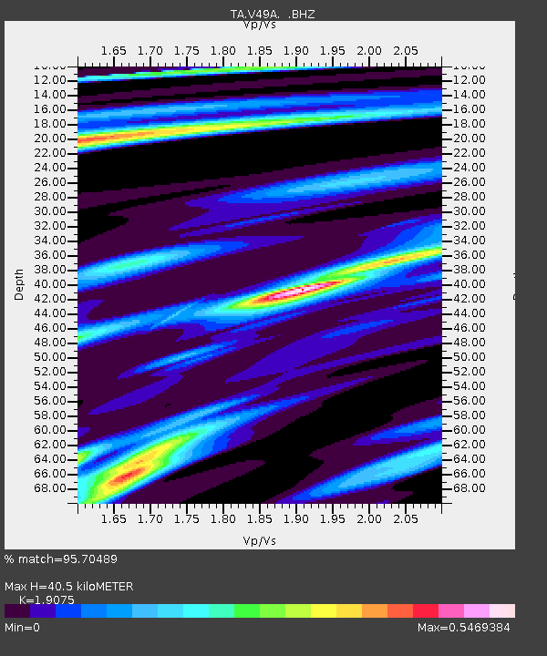
| Estimated Moho Depth: |
40.5 km |
| Estimated Crust Vp/Vs: |
1.91 |
| Assumed Crust Vp: |
6.35 km/s |
| Estimated Crust Vs: |
3.329 km/s |
| Estimated Crust Poisson's Ratio: |
0.31 |
|
| Radial Match: |
95.70489 % |
| Radial Bump: |
282 |
| Transverse Match: |
50.03341 % |
| Transverse Bump: |
400 |
| SOD ConfigId: |
492951 |
| Insert Time: |
2013-04-14 13:18:42.878 +0000 |
| GWidth: |
2.5 |
| Max Bumps: |
400 |
| Tol: |
0.001 |
|
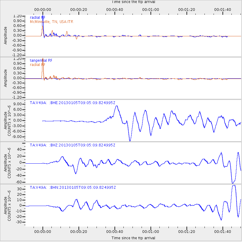
Signal To Noise
| Channel | StoN | STA | LTA |
| TA:V49A: :BHZ:20130105T09:05:09.824995Z | 3.3672888 | 1.0750655E-6 | 3.192674E-7 |
| TA:V49A: :BHN:20130105T09:05:09.824995Z | 2.6560705 | 4.9407686E-7 | 1.8601797E-7 |
| TA:V49A: :BHE:20130105T09:05:09.824995Z | 2.6705992 | 4.5488946E-7 | 1.7033236E-7 |
| Arrivals |
| Ps | 6.2 SECOND |
| PpPs | 17 SECOND |
| PsPs/PpSs | 24 SECOND |


