You are here: Home > Network List > TA - USArray Transportable Network (new EarthScope stations) Stations List
> Station V51A Loudon, TN, USA > Earthquake Result Viewer
V51A Loudon, TN, USA - Earthquake Result Viewer
| Earthquake location: |
Southeastern Alaska |
| Earthquake latitude/longitude: |
55.4/-134.7 |
| Earthquake time(UTC): |
2013/01/05 (005) 08:58:19 GMT |
| Earthquake Depth: |
10 km |
| Earthquake Magnitude: |
6.4 MB, 7.7 MS, 7.5 MW, 7.5 MW |
| Earthquake Catalog/Contributor: |
WHDF/NEIC |
|
| Network: |
TA USArray Transportable Network (new EarthScope stations) |
| Station: |
V51A Loudon, TN, USA |
| Lat/Lon: |
35.80 N/84.35 W |
| Elevation: |
243 m |
|
| Distance: |
39.2 deg |
| Az: |
98.561 deg |
| Baz: |
316.05 deg |
| Ray Param: |
0.07510202 |
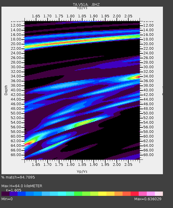
| Estimated Moho Depth: |
64.0 km |
| Estimated Crust Vp/Vs: |
1.61 |
| Assumed Crust Vp: |
6.35 km/s |
| Estimated Crust Vs: |
3.956 km/s |
| Estimated Crust Poisson's Ratio: |
0.18 |
|
| Radial Match: |
94.7895 % |
| Radial Bump: |
214 |
| Transverse Match: |
59.943436 % |
| Transverse Bump: |
400 |
| SOD ConfigId: |
492951 |
| Insert Time: |
2013-04-14 13:19:00.702 +0000 |
| GWidth: |
2.5 |
| Max Bumps: |
400 |
| Tol: |
0.001 |
|

Signal To Noise
| Channel | StoN | STA | LTA |
| TA:V51A: :BHZ:20130105T09:05:16.925001Z | 2.3961508 | 9.235682E-7 | 3.8543828E-7 |
| TA:V51A: :BHN:20130105T09:05:16.925001Z | 1.2976869 | 4.3836556E-7 | 3.3780535E-7 |
| TA:V51A: :BHE:20130105T09:05:16.925001Z | 2.1589 | 4.5495835E-7 | 2.1073619E-7 |
| Arrivals |
| Ps | 6.6 SECOND |
| PpPs | 24 SECOND |
| PsPs/PpSs | 31 SECOND |


