You are here: Home > Network List > TA - USArray Transportable Network (new EarthScope stations) Stations List
> Station S51A Beattyville, KY, USA > Earthquake Result Viewer
S51A Beattyville, KY, USA - Earthquake Result Viewer

| Earthquake location: |
Southeastern Alaska |
| Earthquake latitude/longitude: |
55.4/-134.7 |
| Earthquake time(UTC): |
2013/01/05 (005) 08:58:19 GMT |
| Earthquake Depth: |
10 km |
| Earthquake Magnitude: |
6.4 MB, 7.7 MS, 7.5 MW, 7.5 MW |
| Earthquake Catalog/Contributor: |
WHDF/NEIC |
|
| Network: |
TA USArray Transportable Network (new EarthScope stations) |
| Station: |
S51A Beattyville, KY, USA |
| Lat/Lon: |
37.64 N/83.59 W |
| Elevation: |
286 m |
|
| Distance: |
38.4 deg |
| Az: |
95.811 deg |
| Baz: |
314.357 deg |
| Ray Param: |
0.07560543 |
| Estimated Moho Depth: |
18.0 km |
| Estimated Crust Vp/Vs: |
1.88 |
| Assumed Crust Vp: |
6.476 km/s |
| Estimated Crust Vs: |
3.449 km/s |
| Estimated Crust Poisson's Ratio: |
0.30 |
|
| Radial Match: |
93.42873 % |
| Radial Bump: |
311 |
| Transverse Match: |
86.38914 % |
| Transverse Bump: |
400 |
| SOD ConfigId: |
492951 |
| Insert Time: |
2013-04-14 13:19:42.477 +0000 |
| GWidth: |
2.5 |
| Max Bumps: |
400 |
| Tol: |
0.001 |
|
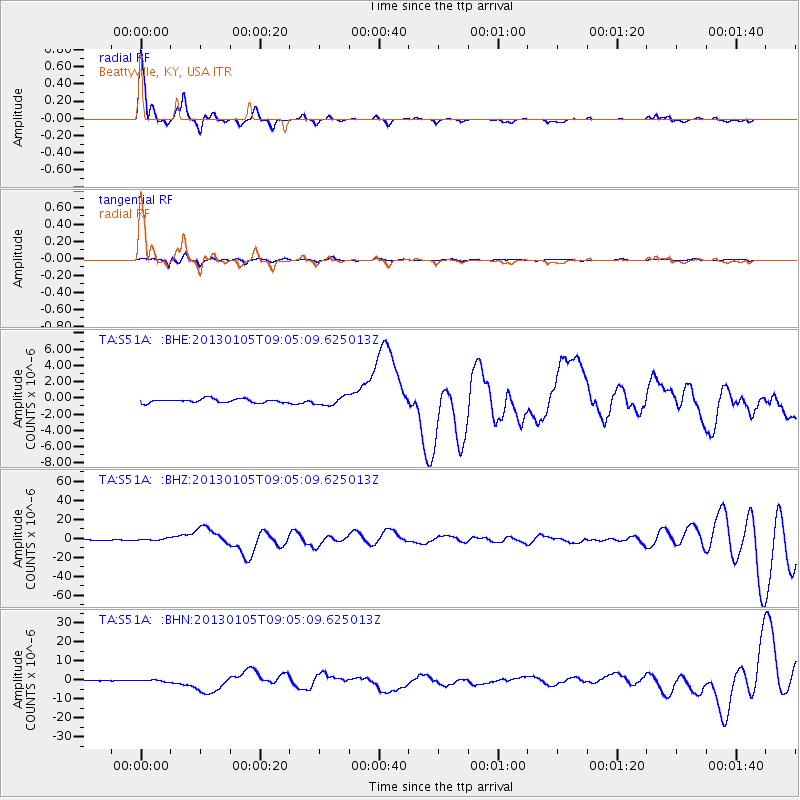
Signal To Noise
| Channel | StoN | STA | LTA |
| TA:S51A: :BHZ:20130105T09:05:09.625013Z | 2.530342 | 9.0286034E-7 | 3.5681356E-7 |
| TA:S51A: :BHN:20130105T09:05:09.625013Z | 3.227165 | 4.9172286E-7 | 1.523699E-7 |
| TA:S51A: :BHE:20130105T09:05:09.625013Z | 2.2995584 | 5.390269E-7 | 2.3440454E-7 |
| Arrivals |
| Ps | 2.6 SECOND |
| PpPs | 7.5 SECOND |
| PsPs/PpSs | 10 SECOND |


