You are here: Home > Network List > TA - USArray Transportable Network (new EarthScope stations) Stations List
> Station S47A Hartford, KY, USA > Earthquake Result Viewer
S47A Hartford, KY, USA - Earthquake Result Viewer
| Earthquake location: |
Southeastern Alaska |
| Earthquake latitude/longitude: |
55.4/-134.7 |
| Earthquake time(UTC): |
2013/01/05 (005) 08:58:19 GMT |
| Earthquake Depth: |
10 km |
| Earthquake Magnitude: |
6.4 MB, 7.7 MS, 7.5 MW, 7.5 MW |
| Earthquake Catalog/Contributor: |
WHDF/NEIC |
|
| Network: |
TA USArray Transportable Network (new EarthScope stations) |
| Station: |
S47A Hartford, KY, USA |
| Lat/Lon: |
37.59 N/86.88 W |
| Elevation: |
181 m |
|
| Distance: |
36.5 deg |
| Az: |
98.873 deg |
| Baz: |
314.793 deg |
| Ray Param: |
0.076627515 |
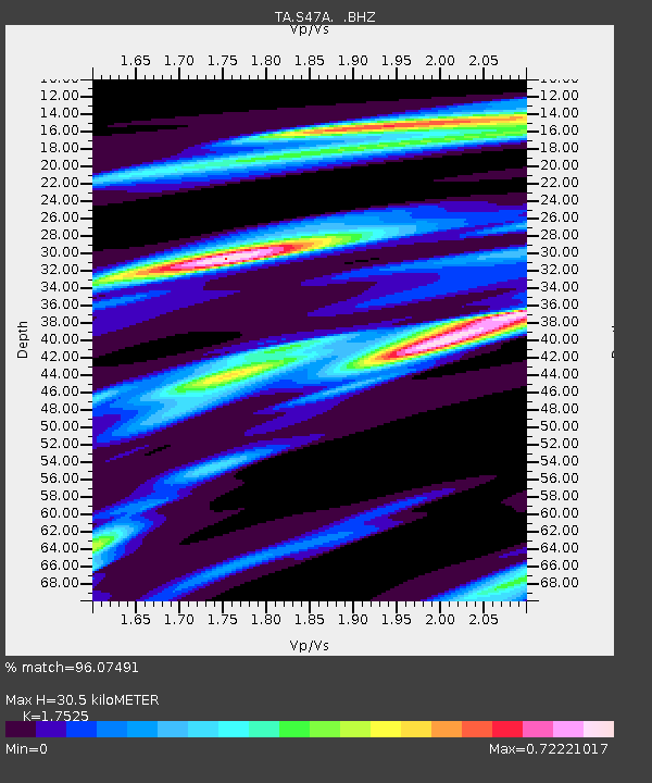
| Estimated Moho Depth: |
30.5 km |
| Estimated Crust Vp/Vs: |
1.75 |
| Assumed Crust Vp: |
6.444 km/s |
| Estimated Crust Vs: |
3.677 km/s |
| Estimated Crust Poisson's Ratio: |
0.26 |
|
| Radial Match: |
96.07491 % |
| Radial Bump: |
189 |
| Transverse Match: |
86.68116 % |
| Transverse Bump: |
377 |
| SOD ConfigId: |
492951 |
| Insert Time: |
2013-04-14 13:21:21.561 +0000 |
| GWidth: |
2.5 |
| Max Bumps: |
400 |
| Tol: |
0.001 |
|

Signal To Noise
| Channel | StoN | STA | LTA |
| TA:S47A: :BHZ:20130105T09:04:54.175001Z | 3.277303 | 1.2421048E-6 | 3.7900213E-7 |
| TA:S47A: :BHN:20130105T09:04:54.175001Z | 3.457827 | 7.749552E-7 | 2.2411623E-7 |
| TA:S47A: :BHE:20130105T09:04:54.175001Z | 1.8579743 | 5.514657E-7 | 2.9681019E-7 |
| Arrivals |
| Ps | 3.8 SECOND |
| PpPs | 12 SECOND |
| PsPs/PpSs | 16 SECOND |


