You are here: Home > Network List > TA - USArray Transportable Network (new EarthScope stations) Stations List
> Station N50A Nevada, OH, USA > Earthquake Result Viewer
N50A Nevada, OH, USA - Earthquake Result Viewer
| Earthquake location: |
Southeastern Alaska |
| Earthquake latitude/longitude: |
55.4/-134.7 |
| Earthquake time(UTC): |
2013/01/05 (005) 08:58:19 GMT |
| Earthquake Depth: |
10 km |
| Earthquake Magnitude: |
6.4 MB, 7.7 MS, 7.5 MW, 7.5 MW |
| Earthquake Catalog/Contributor: |
WHDF/NEIC |
|
| Network: |
TA USArray Transportable Network (new EarthScope stations) |
| Station: |
N50A Nevada, OH, USA |
| Lat/Lon: |
40.77 N/83.15 W |
| Elevation: |
277 m |
|
| Distance: |
36.5 deg |
| Az: |
91.65 deg |
| Baz: |
311.332 deg |
| Ray Param: |
0.07665331 |
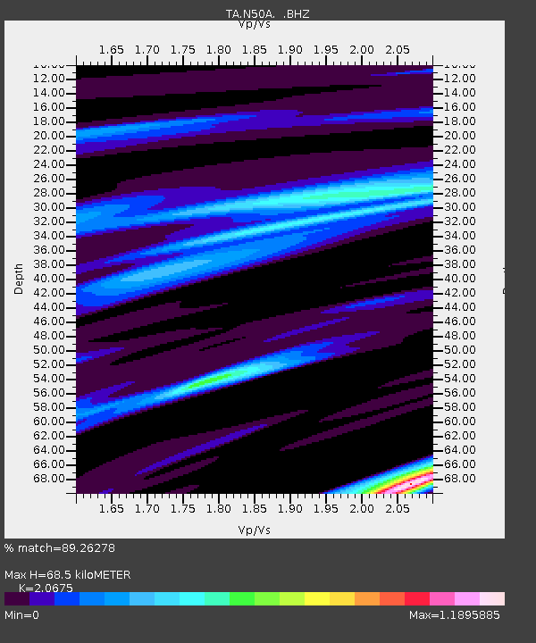
| Estimated Moho Depth: |
68.5 km |
| Estimated Crust Vp/Vs: |
2.07 |
| Assumed Crust Vp: |
6.498 km/s |
| Estimated Crust Vs: |
3.143 km/s |
| Estimated Crust Poisson's Ratio: |
0.35 |
|
| Radial Match: |
89.26278 % |
| Radial Bump: |
400 |
| Transverse Match: |
93.37159 % |
| Transverse Bump: |
372 |
| SOD ConfigId: |
492951 |
| Insert Time: |
2013-04-14 13:21:59.240 +0000 |
| GWidth: |
2.5 |
| Max Bumps: |
400 |
| Tol: |
0.001 |
|
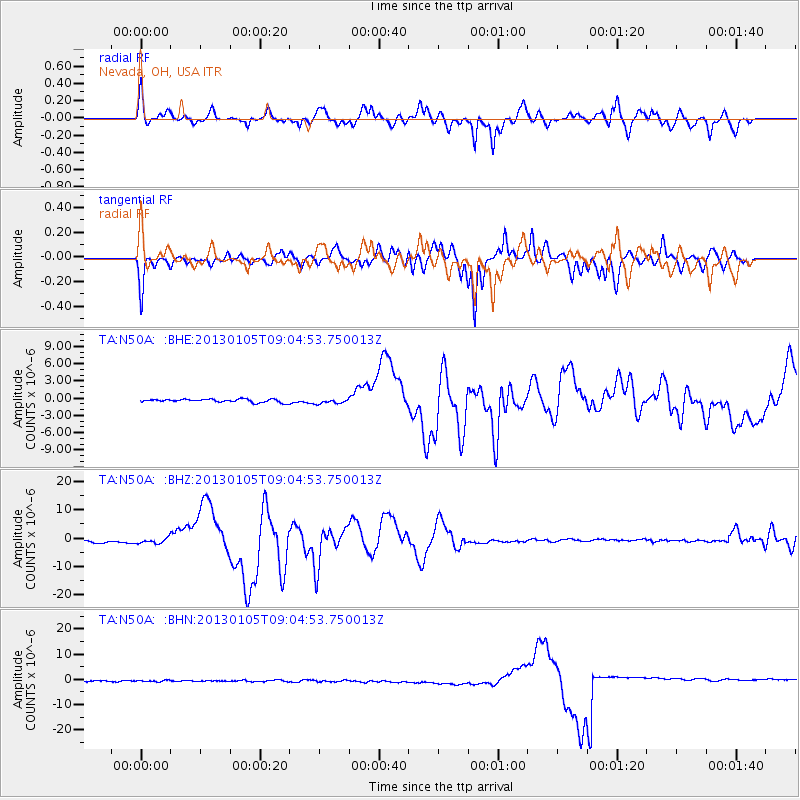
Signal To Noise
| Channel | StoN | STA | LTA |
| TA:N50A: :BHZ:20130105T09:04:53.750013Z | 2.6231158 | 9.3414906E-7 | 3.5612194E-7 |
| TA:N50A: :BHN:20130105T09:04:53.750013Z | 1.1735331 | 3.0171648E-7 | 2.5710096E-7 |
| TA:N50A: :BHE:20130105T09:04:53.750013Z | 1.513016 | 4.158012E-7 | 2.7481613E-7 |
| Arrivals |
| Ps | 12 SECOND |
| PpPs | 30 SECOND |
| PsPs/PpSs | 42 SECOND |


