You are here: Home > Network List > TA - USArray Transportable Network (new EarthScope stations) Stations List
> Station O49A Covington, OH, USA > Earthquake Result Viewer
O49A Covington, OH, USA - Earthquake Result Viewer
| Earthquake location: |
Southeastern Alaska |
| Earthquake latitude/longitude: |
55.4/-134.7 |
| Earthquake time(UTC): |
2013/01/05 (005) 08:58:19 GMT |
| Earthquake Depth: |
10 km |
| Earthquake Magnitude: |
6.4 MB, 7.7 MS, 7.5 MW, 7.5 MW |
| Earthquake Catalog/Contributor: |
WHDF/NEIC |
|
| Network: |
TA USArray Transportable Network (new EarthScope stations) |
| Station: |
O49A Covington, OH, USA |
| Lat/Lon: |
40.19 N/84.34 W |
| Elevation: |
292 m |
|
| Distance: |
36.2 deg |
| Az: |
93.4 deg |
| Baz: |
311.974 deg |
| Ray Param: |
0.07681089 |
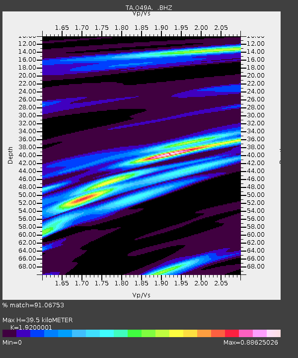
| Estimated Moho Depth: |
39.5 km |
| Estimated Crust Vp/Vs: |
1.92 |
| Assumed Crust Vp: |
6.498 km/s |
| Estimated Crust Vs: |
3.384 km/s |
| Estimated Crust Poisson's Ratio: |
0.31 |
|
| Radial Match: |
91.06753 % |
| Radial Bump: |
280 |
| Transverse Match: |
67.3794 % |
| Transverse Bump: |
400 |
| SOD ConfigId: |
492951 |
| Insert Time: |
2013-04-14 13:22:10.690 +0000 |
| GWidth: |
2.5 |
| Max Bumps: |
400 |
| Tol: |
0.001 |
|

Signal To Noise
| Channel | StoN | STA | LTA |
| TA:O49A: :BHZ:20130105T09:04:51.300001Z | 2.6566355 | 9.4701426E-7 | 3.564713E-7 |
| TA:O49A: :BHN:20130105T09:04:51.300001Z | 1.3464891 | 3.8675336E-7 | 2.8723096E-7 |
| TA:O49A: :BHE:20130105T09:04:51.300001Z | 1.8762101 | 6.083292E-7 | 3.2423296E-7 |
| Arrivals |
| Ps | 6.0 SECOND |
| PpPs | 17 SECOND |
| PsPs/PpSs | 23 SECOND |


