You are here: Home > Network List > TA - USArray Transportable Network (new EarthScope stations) Stations List
> Station P49A Miami Univ. Ecology Research Center, OH, USA > Earthquake Result Viewer
P49A Miami Univ. Ecology Research Center, OH, USA - Earthquake Result Viewer
| Earthquake location: |
Southeastern Alaska |
| Earthquake latitude/longitude: |
55.4/-134.7 |
| Earthquake time(UTC): |
2013/01/05 (005) 08:58:19 GMT |
| Earthquake Depth: |
10 km |
| Earthquake Magnitude: |
6.4 MB, 7.7 MS, 7.5 MW, 7.5 MW |
| Earthquake Catalog/Contributor: |
WHDF/NEIC |
|
| Network: |
TA USArray Transportable Network (new EarthScope stations) |
| Station: |
P49A Miami Univ. Ecology Research Center, OH, USA |
| Lat/Lon: |
39.53 N/84.72 W |
| Elevation: |
272 m |
|
| Distance: |
36.4 deg |
| Az: |
94.549 deg |
| Baz: |
312.657 deg |
| Ray Param: |
0.07668956 |
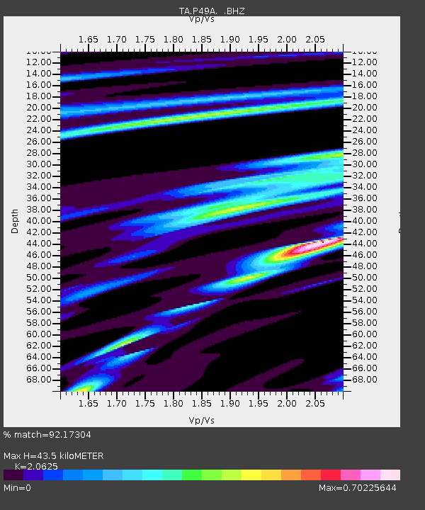
| Estimated Moho Depth: |
43.5 km |
| Estimated Crust Vp/Vs: |
2.06 |
| Assumed Crust Vp: |
6.498 km/s |
| Estimated Crust Vs: |
3.15 km/s |
| Estimated Crust Poisson's Ratio: |
0.35 |
|
| Radial Match: |
92.17304 % |
| Radial Bump: |
191 |
| Transverse Match: |
59.24168 % |
| Transverse Bump: |
400 |
| SOD ConfigId: |
492951 |
| Insert Time: |
2013-04-14 13:23:10.889 +0000 |
| GWidth: |
2.5 |
| Max Bumps: |
400 |
| Tol: |
0.001 |
|

Signal To Noise
| Channel | StoN | STA | LTA |
| TA:P49A: :BHZ:20130105T09:04:53.199995Z | 3.1484995 | 1.138785E-6 | 3.6169135E-7 |
| TA:P49A: :BHN:20130105T09:04:53.199995Z | 2.4378176 | 5.5111263E-7 | 2.2606804E-7 |
| TA:P49A: :BHE:20130105T09:04:53.199995Z | 1.3601749 | 3.9926599E-7 | 2.935402E-7 |
| Arrivals |
| Ps | 7.6 SECOND |
| PpPs | 19 SECOND |
| PsPs/PpSs | 27 SECOND |


