You are here: Home > Network List > TA - USArray Transportable Network (new EarthScope stations) Stations List
> Station L48A N Adams, MI, USA > Earthquake Result Viewer
L48A N Adams, MI, USA - Earthquake Result Viewer
| Earthquake location: |
Southeastern Alaska |
| Earthquake latitude/longitude: |
55.4/-134.7 |
| Earthquake time(UTC): |
2013/01/05 (005) 08:58:19 GMT |
| Earthquake Depth: |
10 km |
| Earthquake Magnitude: |
6.4 MB, 7.7 MS, 7.5 MW, 7.5 MW |
| Earthquake Catalog/Contributor: |
WHDF/NEIC |
|
| Network: |
TA USArray Transportable Network (new EarthScope stations) |
| Station: |
L48A N Adams, MI, USA |
| Lat/Lon: |
41.94 N/84.43 W |
| Elevation: |
369 m |
|
| Distance: |
35.0 deg |
| Az: |
91.21 deg |
| Baz: |
310.13 deg |
| Ray Param: |
0.07745575 |
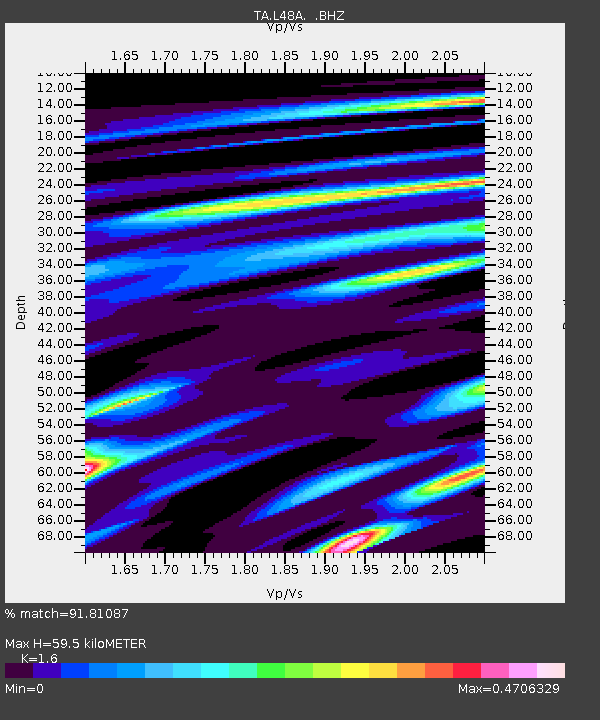
| Estimated Moho Depth: |
59.5 km |
| Estimated Crust Vp/Vs: |
1.60 |
| Assumed Crust Vp: |
6.498 km/s |
| Estimated Crust Vs: |
4.061 km/s |
| Estimated Crust Poisson's Ratio: |
0.18 |
|
| Radial Match: |
91.81087 % |
| Radial Bump: |
232 |
| Transverse Match: |
92.89471 % |
| Transverse Bump: |
333 |
| SOD ConfigId: |
492951 |
| Insert Time: |
2013-04-14 13:23:42.172 +0000 |
| GWidth: |
2.5 |
| Max Bumps: |
400 |
| Tol: |
0.001 |
|
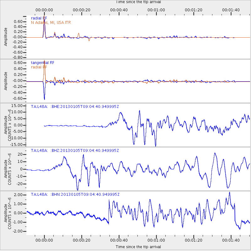
Signal To Noise
| Channel | StoN | STA | LTA |
| TA:L48A: :BHZ:20130105T09:04:40.949995Z | 2.2923696 | 9.1537595E-7 | 3.9931427E-7 |
| TA:L48A: :BHN:20130105T09:04:40.949995Z | 0.45592368 | 2.2512309E-7 | 4.937736E-7 |
| TA:L48A: :BHE:20130105T09:04:40.949995Z | 2.6753106 | 6.914322E-7 | 2.5844932E-7 |
| Arrivals |
| Ps | 6.0 SECOND |
| PpPs | 22 SECOND |
| PsPs/PpSs | 28 SECOND |


