You are here: Home > Network List > TA - USArray Transportable Network (new EarthScope stations) Stations List
> Station P51A Williamsport, OH, USA > Earthquake Result Viewer
P51A Williamsport, OH, USA - Earthquake Result Viewer
| Earthquake location: |
Southeastern Alaska |
| Earthquake latitude/longitude: |
55.4/-134.7 |
| Earthquake time(UTC): |
2013/01/05 (005) 08:58:19 GMT |
| Earthquake Depth: |
10 km |
| Earthquake Magnitude: |
6.4 MB, 7.7 MS, 7.5 MW, 7.5 MW |
| Earthquake Catalog/Contributor: |
WHDF/NEIC |
|
| Network: |
TA USArray Transportable Network (new EarthScope stations) |
| Station: |
P51A Williamsport, OH, USA |
| Lat/Lon: |
39.48 N/83.06 W |
| Elevation: |
211 m |
|
| Distance: |
37.4 deg |
| Az: |
93.168 deg |
| Baz: |
312.602 deg |
| Ray Param: |
0.07615666 |
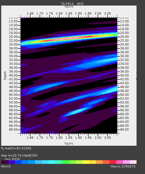
| Estimated Moho Depth: |
20.75 km |
| Estimated Crust Vp/Vs: |
1.83 |
| Assumed Crust Vp: |
6.232 km/s |
| Estimated Crust Vs: |
3.401 km/s |
| Estimated Crust Poisson's Ratio: |
0.29 |
|
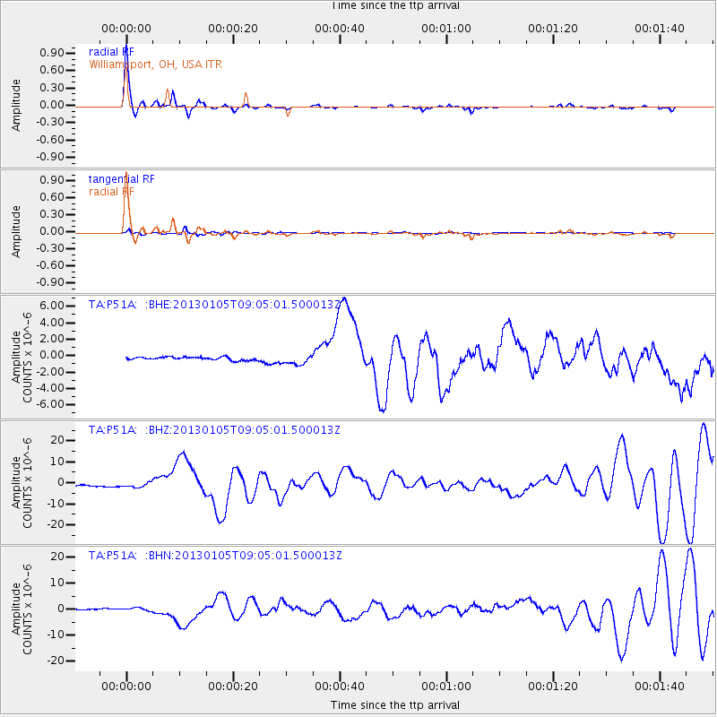
| Radial Match: |
92.42488 % |
| Radial Bump: |
223 |
| Transverse Match: |
76.071915 % |
| Transverse Bump: |
318 |
| SOD ConfigId: |
492951 |
| Insert Time: |
2013-04-14 13:24:01.255 +0000 |
| GWidth: |
2.5 |
| Max Bumps: |
400 |
| Tol: |
0.001 |
|
Signal To Noise
| Channel | StoN | STA | LTA |
| TA:P51A: :BHZ:20130105T09:05:01.500013Z | 3.017905 | 1.0865866E-6 | 3.6004667E-7 |
| TA:P51A: :BHN:20130105T09:05:01.500013Z | 3.6943736 | 6.285431E-7 | 1.7013522E-7 |
| TA:P51A: :BHE:20130105T09:05:01.500013Z | 3.179436 | 6.064726E-7 | 1.907485E-7 |
| Arrivals |
| Ps | 3.0 SECOND |
| PpPs | 8.8 SECOND |
| PsPs/PpSs | 12 SECOND |


