You are here: Home > Network List > TA - USArray Transportable Network (new EarthScope stations) Stations List
> Station L46A Eue Claire, MI, USA > Earthquake Result Viewer
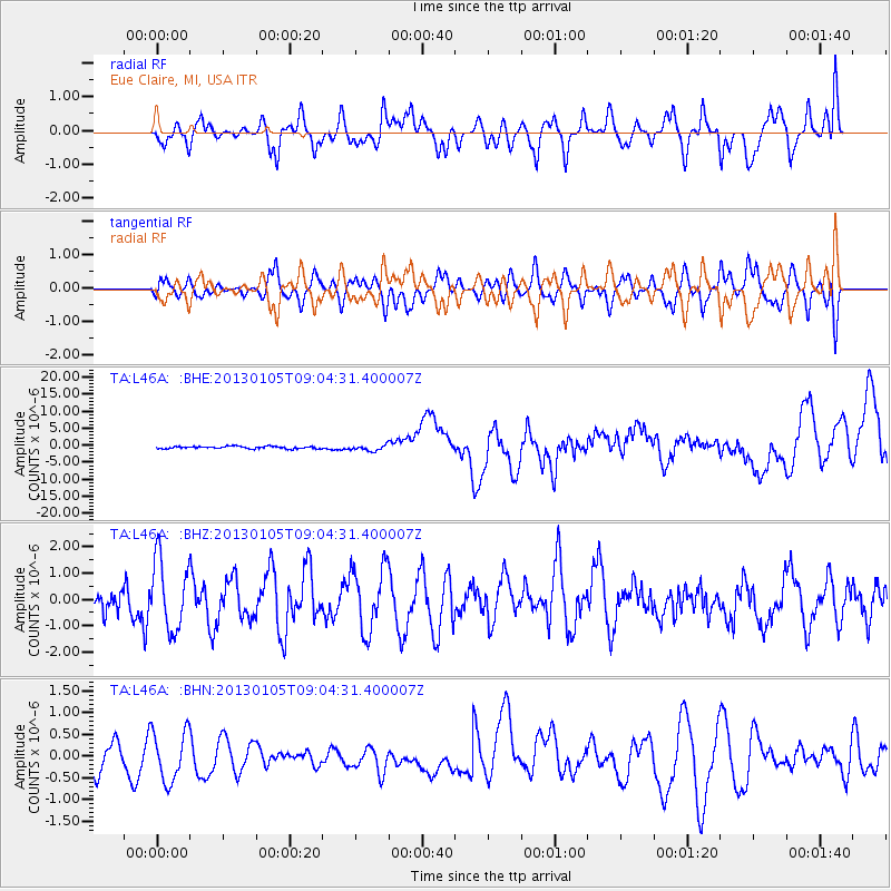
L46A Eue Claire, MI, USA - Earthquake Result Viewer
*The percent match for this event was below the threshold and hence no stack was calculated.
| Earthquake location: |
Southeastern Alaska |
| Earthquake latitude/longitude: |
55.4/-134.7 |
| Earthquake time(UTC): |
2013/01/05 (005) 08:58:19 GMT |
| Earthquake Depth: |
10 km |
| Earthquake Magnitude: |
6.4 MB, 7.7 MS, 7.5 MW, 7.5 MW |
| Earthquake Catalog/Contributor: |
WHDF/NEIC |
|
| Network: |
TA USArray Transportable Network (new EarthScope stations) |
| Station: |
L46A Eue Claire, MI, USA |
| Lat/Lon: |
42.01 N/86.30 W |
| Elevation: |
223 m |
|
| Distance: |
33.9 deg |
| Az: |
92.7 deg |
| Baz: |
310.117 deg |
| Ray Param: |
$rayparam |
*The percent match for this event was below the threshold and hence was not used in the summary stack. |
|
| Radial Match: |
57.458843 % |
| Radial Bump: |
357 |
| Transverse Match: |
57.478386 % |
| Transverse Bump: |
398 |
| SOD ConfigId: |
492951 |
| Insert Time: |
2013-04-14 13:25:54.608 +0000 |
| GWidth: |
2.5 |
| Max Bumps: |
400 |
| Tol: |
0.001 |
|
Signal To Noise
| Channel | StoN | STA | LTA |
| TA:L46A: :BHZ:20130105T09:04:31.400007Z | 1.0725803 | 1.3120417E-6 | 1.2232573E-6 |
| TA:L46A: :BHN:20130105T09:04:31.400007Z | 1.072854 | 5.9526536E-7 | 5.5484287E-7 |
| TA:L46A: :BHE:20130105T09:04:31.400007Z | 2.4513845 | 8.4554915E-7 | 3.449272E-7 |
| Arrivals |
| Ps | |
| PpPs | |
| PsPs/PpSs | |


