You are here: Home > Network List > TA - USArray Transportable Network (new EarthScope stations) Stations List
> Station H56A Elgin, ON, CAN > Earthquake Result Viewer
H56A Elgin, ON, CAN - Earthquake Result Viewer

| Earthquake location: |
Southeastern Alaska |
| Earthquake latitude/longitude: |
55.4/-134.7 |
| Earthquake time(UTC): |
2013/01/05 (005) 08:58:19 GMT |
| Earthquake Depth: |
10 km |
| Earthquake Magnitude: |
6.4 MB, 7.7 MS, 7.5 MW, 7.5 MW |
| Earthquake Catalog/Contributor: |
WHDF/NEIC |
|
| Network: |
TA USArray Transportable Network (new EarthScope stations) |
| Station: |
H56A Elgin, ON, CAN |
| Lat/Lon: |
44.59 N/76.26 W |
| Elevation: |
137 m |
|
| Distance: |
38.0 deg |
| Az: |
81.434 deg |
| Baz: |
307.849 deg |
| Ray Param: |
0.075828426 |
| Estimated Moho Depth: |
19.0 km |
| Estimated Crust Vp/Vs: |
1.66 |
| Assumed Crust Vp: |
6.577 km/s |
| Estimated Crust Vs: |
3.962 km/s |
| Estimated Crust Poisson's Ratio: |
0.22 |
|
| Radial Match: |
95.30594 % |
| Radial Bump: |
211 |
| Transverse Match: |
85.601654 % |
| Transverse Bump: |
400 |
| SOD ConfigId: |
492951 |
| Insert Time: |
2013-04-14 13:29:45.094 +0000 |
| GWidth: |
2.5 |
| Max Bumps: |
400 |
| Tol: |
0.001 |
|
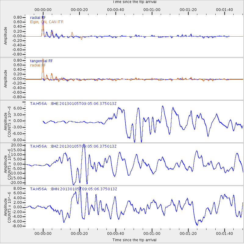
Signal To Noise
| Channel | StoN | STA | LTA |
| TA:H56A: :BHZ:20130105T09:05:06.375013Z | 1.7401667 | 7.835359E-7 | 4.5026485E-7 |
| TA:H56A: :BHN:20130105T09:05:06.375013Z | 1.2378657 | 3.668804E-7 | 2.9638142E-7 |
| TA:H56A: :BHE:20130105T09:05:06.375013Z | 1.5671479 | 4.6611112E-7 | 2.974264E-7 |
| Arrivals |
| Ps | 2.1 SECOND |
| PpPs | 7.1 SECOND |
| PsPs/PpSs | 9.1 SECOND |


