You are here: Home > Network List > TA - USArray Transportable Network (new EarthScope stations) Stations List
> Station O55A Ligonier, PA, USA > Earthquake Result Viewer
O55A Ligonier, PA, USA - Earthquake Result Viewer
| Earthquake location: |
Southeastern Alaska |
| Earthquake latitude/longitude: |
55.4/-134.7 |
| Earthquake time(UTC): |
2013/01/05 (005) 08:58:19 GMT |
| Earthquake Depth: |
10 km |
| Earthquake Magnitude: |
6.4 MB, 7.7 MS, 7.5 MW, 7.5 MW |
| Earthquake Catalog/Contributor: |
WHDF/NEIC |
|
| Network: |
TA USArray Transportable Network (new EarthScope stations) |
| Station: |
O55A Ligonier, PA, USA |
| Lat/Lon: |
40.21 N/79.30 W |
| Elevation: |
469 m |
|
| Distance: |
39.1 deg |
| Az: |
89.16 deg |
| Baz: |
311.85 deg |
| Ray Param: |
0.07520553 |
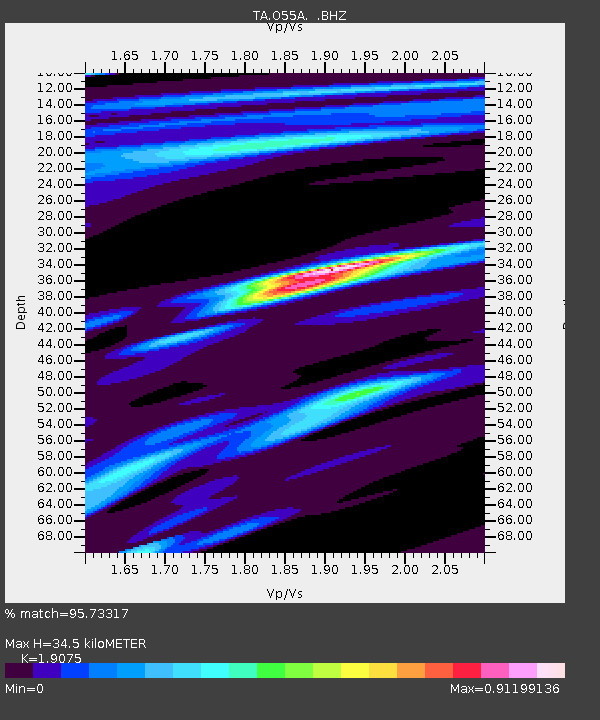
| Estimated Moho Depth: |
34.5 km |
| Estimated Crust Vp/Vs: |
1.91 |
| Assumed Crust Vp: |
6.121 km/s |
| Estimated Crust Vs: |
3.209 km/s |
| Estimated Crust Poisson's Ratio: |
0.31 |
|
| Radial Match: |
95.73317 % |
| Radial Bump: |
229 |
| Transverse Match: |
71.06596 % |
| Transverse Bump: |
400 |
| SOD ConfigId: |
492951 |
| Insert Time: |
2013-04-14 13:31:11.077 +0000 |
| GWidth: |
2.5 |
| Max Bumps: |
400 |
| Tol: |
0.001 |
|
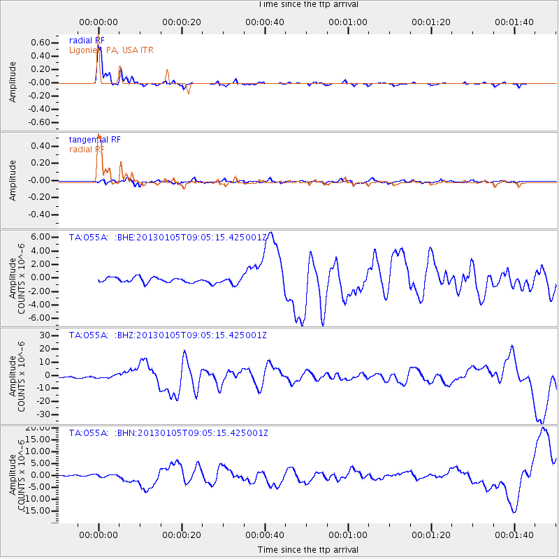
Signal To Noise
| Channel | StoN | STA | LTA |
| TA:O55A: :BHZ:20130105T09:05:15.425001Z | 2.1425877 | 1.1538199E-6 | 5.38517E-7 |
| TA:O55A: :BHN:20130105T09:05:15.425001Z | 1.7267594 | 4.6740277E-7 | 2.7068205E-7 |
| TA:O55A: :BHE:20130105T09:05:15.425001Z | 1.3910241 | 4.9471805E-7 | 3.5565023E-7 |
| Arrivals |
| Ps | 5.4 SECOND |
| PpPs | 15 SECOND |
| PsPs/PpSs | 21 SECOND |


