You are here: Home > Network List > CN - Canadian National Seismograph Network Stations List
> Station INK INUVIK, NT > Earthquake Result Viewer
INK INUVIK, NT - Earthquake Result Viewer
*The percent match for this event was below the threshold and hence no stack was calculated.
| Earthquake location: |
Myanmar-India Border Region |
| Earthquake latitude/longitude: |
25.3/95.0 |
| Earthquake time(UTC): |
2013/01/09 (009) 01:41:53 GMT |
| Earthquake Depth: |
93 km |
| Earthquake Magnitude: |
5.8 MB, 5.8 MW, 5.8 MW |
| Earthquake Catalog/Contributor: |
WHDF/NEIC |
|
| Network: |
CN Canadian National Seismograph Network |
| Station: |
INK INUVIK, NT |
| Lat/Lon: |
68.31 N/133.53 W |
| Elevation: |
44 m |
|
| Distance: |
80.1 deg |
| Az: |
16.44 deg |
| Baz: |
316.46 deg |
| Ray Param: |
$rayparam |
*The percent match for this event was below the threshold and hence was not used in the summary stack. |
|
| Radial Match: |
57.23464 % |
| Radial Bump: |
400 |
| Transverse Match: |
68.56265 % |
| Transverse Bump: |
400 |
| SOD ConfigId: |
493637 |
| Insert Time: |
2013-04-16 13:32:17.654 +0000 |
| GWidth: |
2.5 |
| Max Bumps: |
400 |
| Tol: |
0.001 |
|
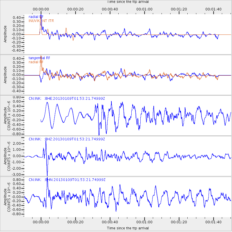
Signal To Noise
| Channel | StoN | STA | LTA |
| CN:INK: :BHZ:20130109T01:53:21.74999Z | 6.787024 | 1.1015721E-6 | 1.6230562E-7 |
| CN:INK: :BHN:20130109T01:53:21.74999Z | 2.1298695 | 3.438855E-7 | 1.6145849E-7 |
| CN:INK: :BHE:20130109T01:53:21.74999Z | 1.2921747 | 3.5313246E-7 | 2.7328537E-7 |
| Arrivals |
| Ps | |
| PpPs | |
| PsPs/PpSs | |


