You are here: Home > Network List > G - GEOSCOPE Stations List
> Station ATD Arta Cave - Arta, Republic of Djibouti > Earthquake Result Viewer
ATD Arta Cave - Arta, Republic of Djibouti - Earthquake Result Viewer
| Earthquake location: |
Myanmar-India Border Region |
| Earthquake latitude/longitude: |
25.3/95.0 |
| Earthquake time(UTC): |
2013/01/09 (009) 01:41:53 GMT |
| Earthquake Depth: |
93 km |
| Earthquake Magnitude: |
5.8 MB, 5.8 MW, 5.8 MW |
| Earthquake Catalog/Contributor: |
WHDF/NEIC |
|
| Network: |
G GEOSCOPE |
| Station: |
ATD Arta Cave - Arta, Republic of Djibouti |
| Lat/Lon: |
11.53 N/42.85 E |
| Elevation: |
610 m |
|
| Distance: |
51.1 deg |
| Az: |
264.407 deg |
| Baz: |
66.776 deg |
| Ray Param: |
0.06734936 |
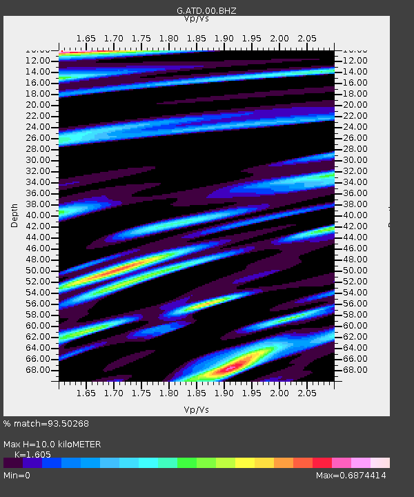
| Estimated Moho Depth: |
10.0 km |
| Estimated Crust Vp/Vs: |
1.61 |
| Assumed Crust Vp: |
6.375 km/s |
| Estimated Crust Vs: |
3.972 km/s |
| Estimated Crust Poisson's Ratio: |
0.18 |
|
| Radial Match: |
93.50268 % |
| Radial Bump: |
400 |
| Transverse Match: |
85.77764 % |
| Transverse Bump: |
400 |
| SOD ConfigId: |
493637 |
| Insert Time: |
2013-04-16 13:34:15.429 +0000 |
| GWidth: |
2.5 |
| Max Bumps: |
400 |
| Tol: |
0.001 |
|
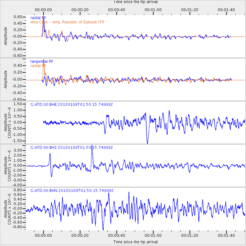
Signal To Noise
| Channel | StoN | STA | LTA |
| G:ATD:00:BHZ:20130109T01:50:15.74999Z | 16.284468 | 9.769442E-7 | 5.99924E-8 |
| G:ATD:00:BHN:20130109T01:50:15.74999Z | 2.2407265 | 1.3962519E-7 | 6.2312466E-8 |
| G:ATD:00:BHE:20130109T01:50:15.74999Z | 4.4023833 | 3.1372767E-7 | 7.126314E-8 |
| Arrivals |
| Ps | 1.0 SECOND |
| PpPs | 3.8 SECOND |
| PsPs/PpSs | 4.9 SECOND |


